Bands of rain have been passing over the area off and on all day as Ida moved closer to the Northwest Florida coast. The wind is starting to gust now. Tim put up the small yard waste cans; the large garbage cans ought to be all right. The regular trash has some big bags of cat litter in it which should help hold it down. In addition, we piled in some small limbs that had been sitting in the back yard for a while. Our workplaces both shut down early today, which gave us a chance to get those last minute preps done while we still had daylight.
I'm charging my cell phone, and I really ought not to be running the laptop off battery, but it's easier, and I don't expect to lose power. I'll plug it in later to top off the charge, then unplug it when things get bad to protect against surges.
Today, the National Hurricane Center has taken the line off the graphic showing the projected path. Perhaps too many people are focusing on that line and not on the fact that this is a large storm with tropical storm force winds extending 200 miles from the center. That means, the storm is 400 miles across, and even if you're on the very edge of the storm, you will experience sustained winds of 38mph or more.
Ida will not, for most people, be catastrophic, however, hurricanes and tropical storms can spin off tornados. Sustained high winds over several hours can break a weak limb, pull up a loose shingle, and cause other damage. Nothing to worry about unless it's your house that suddenly springs a leak or your car that has a broken windshield from a broken branch.
Now, while tropical storms and National Hurricane Advisories are on everyone's mind, the NHC is looking for input about how their public advisories are presented. Take a moment and go to the NHC's discussion page. They present several examples of public advisories prepared in the current style and the proposed new style. Compare them, then drop the NHC a note letting them know what you like and don't like. This will determine how information is presented in the future.
Monday, November 9, 2009
Sunday, November 8, 2009
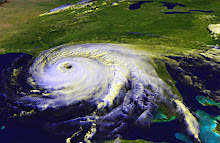
Ida makes beeline for Northwest Florida
Hurricane Ida is a Category 2 storm expected to make landfall in Pensacola or thereabouts early on Tuesday. The Pensacola News Journal has some updates on school closings. If you read the comments on the PNJ's website, you'll get the impression that the locals aren't taking this seriously, except as an excuse to get out of going to work or school.
We were gone to an event all day today, so we really haven't done any preparations. Depending on the latest track on Monday afternoon, we may cover our large living room window after work. At this point, the storm is expected to lose quite a bit of steam before making landfall, in large part because of cooler water temps near the coast. We did buy some extra water on Saturday, we have our supply of GoPicnic meals, as well as peanut butter and canned tuna, so we'll be okay. If we should lose power for more than a day, we can drag out the generator (and hope we can get some gas to go in it). However, I'm not anticipating more than a few hours without power, if we lose it at all.
The most important thing will be to take a look around your home, keeping an eye out for anything that can be caught in the wind: loose limbs that could be trimmed before the storm gets here, a piece of shingle or loose gutter that could be tacked down befor the wind tears it away. Pick up toys, put up patio furniture. Anything that can be blown around by a strong gust of wind can become a missile that breaks windows, dents cars, and causes other damage.
It's great that people aren't panicking about Ida, but nor should they (or you, if you're in the path) believe that this storm will not be capable of damage. Any tropical storm has the ability to cause wind damage and flooding. Be proactive for the safety of your home and family and for the people around you.
Saturday, November 7, 2009
Ida is a tropical storm again.
The Florida panhandle is definitely going to feel some effects from Tropical Storm Ida in a couple of days. All the computer models show it crossing or at least coming near Northwest Florida. The official track is pointing it a bit more towards Panama City, but of course, areas to the west and east are still in the cone of uncertainty. Also, the storm's wind and rain will extend far beyond a single point on the map. Folks in low lying areas should prepare for storm surge as well. Even if Ida is "only" a tropical storm, it could still cause flooding from rising waters as well as rainfall. It's probably a good idea to secure anything that can blow around. We don't know what kind of winds we'll feel, and it's better to be safe than sorry.
Friday, November 6, 2009
Ida expected to re-strengthen
As of noon Friday, Ida is over land and down to tropical depression status. Soon, however, the system will move back over the water and head towards the Gulf of Mexico, where water temperatures are in the mid-80s, and warmer waters feed and strengthen tropical weather systems. Forecasters say Ida could reach hurricane strength again. The National Hurricane Center is anticipating that the storm will travel north for a bit and then turn east into Florida. Computer models are all over the place, with some moving the storm towards Texas or Louisiana, then possibly turn east. Others are following variations of the NHC's track (or rather, the NHC forecasters are putting more trust in those models that head east).
Fortunately, the waters near the coast of Florida are cooler than in the middle of the Gulf. That should help weaken Ida before she makes landfall.
Let's all keep an eye on this storm and be ready to take action to protect our homes and families if she heads our way.
Fortunately, the waters near the coast of Florida are cooler than in the middle of the Gulf. That should help weaken Ida before she makes landfall.
Let's all keep an eye on this storm and be ready to take action to protect our homes and families if she heads our way.
Thursday, November 5, 2009
A Hurricane in Novemberr?!
Hurricane Ida is now swirling in the waters off Nicaragua. That's right, a full-fledged Category 1 hurricane has formed in November.
Hurricane season ends November 30, and it's not unprecedented to see tropical storms and hurricanes this late in the year. A couple of times in recent memory, we've even had named storms develop in December. Aren't those pesky storms watching the calendar?
The National Hurricane Center has the storm crossing Nicaragua and Honduras, losing strength over land, then moving back over the open water, strengthening to tropical storm status and heading into the Gulf.
The good news is, the waters are cooling, so the storm shouldn't gain a lot of strength. It still has the potential to cause some wind damage and flooding upon landfall.
The ensemble models are all over the place, but at this point, if you live on the Gulf Coast, you should begin watching the National Hurricane Center for updates. I'll be checking my stock of canned goods, and I just received a package of six GoPicnic meals through an online giveaway. If the storm hits Pensacola and power gets knocked out, I'll be okay until they get it turned back on. I don't expect this to be a two-weeks-without-power experience, just a couple or three days at most.
At this point in the season, I'm a little calmer, because I don't expect a monster storm. Please, Mother Nature, don't prove me wrong! If you live in an area that could be targeted by Ida, do what I'm doing and watch the track, check for a few supplies, and don't stock up on refrigerated foods.
Tuesday, October 13, 2009
Be ready with an ICE-QUBE.
Having dealt with three major hurricanes in 2004-2005, I am well aware how important it is to be prepared for disaster. Hurricanes aren't the only threat to our security. Terrorism, blackouts, earthquakes, tornadoes, floods, snowstorms, volcanoes (thankfully, our homeowner's insurance does cover volcanic activity) or even a pandemic disease could leave us scrambling to survive.
That's why it's important to have an emergency kit, whether it's something you put together yourself or something you buy.
I was fortunate enough to win a small ICE-QUBE emergency kit from another blog, MommyPR and ICE-QUBE, so I have a chance to review it here. Now, I was expecting the Starter Kit, which retails for $19.99, so I was quite pleasantly surprised to find that they'd sent me their ICE-QUBE To Go, which retails for $149.00!
I'm copying the list of contents from the ICE-QUBE website and I'll give my thoughts next to each:
AM/FM Radio with flashlight, siren and hand-crank - this is a little different than is pictured on the website, but I wound the crank a few times and I was able to test the flashlight and tune in a couple of radio stations (AM and FM). It's not a really bright light to work by, but it would be nice for finding your way in the dark and you don't have to worry about finding fresh batteries. The radio got a clear signal for listening to news and official updates.
Energy Pills - it's a small package of pills. Not sure how well they work, but it's hard work cleaning up after a natural disaster, so hopefully they'll provide some pep.
Face Shield - this is one of those dust mask, cup style paper face mask. It will help filter some dust if you're clearing debris or dealing with smoke and ash. It could also be useful for some medical emergencies, though I don't know how well it will filter germs. Note: this is a different style than what is pictured on the website, and you get one, not several.
First-Aid Kit:
Alcohol Wipes
Antiseptic Wipes
Bandages
Burn Cream
Cleansing Wipes
Ice Pack
Medical Grade Gloves
Tweezers
First Aid Reference Guide
The first aid kit is all packed in a cloth case with a carabiner-style clip on one corner, so you can snap it on a belt loop or backpack. There's not a lot of any one thing, but it's a nice assortment to deal with minor injuries.
ICE Emergency Plan is a card that you fill out with contact numbers, such as work, school, family contacts, doctor and insurance company phone numbers, and pre-agreed information like where the emergency family meeting place is and who will be the family's point of contact out-of-town (this is where you tell everyone you know that if your hometown is hit by a hurricane, you're going to call Aunt Jane in Minnesota and then everyone can call her instead of trying to get through to you right after the storm).
Marker - I'm not sure how long this will stay functional in a closet, but it's good to have a heavy-duty marker to write your FEMA or Blue Roof number on your house or to make "no trespassing" or "danger" signs if you have serious damage.
Multi-tool - a handy small tool in a cloth case, kind of like a Swiss Army Knife. It could be good for pulling nails out of boards, and that kind of minor situation.
Mylar blanket - shiny silver for signaling for help. Great for keeping warm after a blizzard. Well, it's supposed to help you keep warm. Not living the frozen north, I don't know how well it would work. It is plastic, so you might be able to use it like a tarp to block a leak.
Rain Poncho - handy to have if you have to get out in the rain, although in a hurricane, it probably won't really keep you dry.
Rope - This looks smaller than what is pictured. It's more like cord than rope, but it's 50' of nylon that could be used to tie down a tarp or secure something that's in danger of falling.
Tarp/Tube Tent - It's made of a pretty thin material, but it's better than nothing to help block a leak or cover some of your belongings if they're getting wet. I can't think of many situations that would require camping out, but it could provide some shade if you're working outside in the sun. This may be something more appropriate to keep in the car in case something happens while you're on the road. It's bright orange, so it could be used as a signal as well. It is packaged with a small coil of cord.
Thermometer - this is a paper or plastic lay-it-on-your-head thermometer that is packed in the first aid kit.
Whistle - a nice shiny metal whistle to signal for help.
Waterproof Document Pouch - it's a zipper-sealed plastic bag, but it is thicker plastic and larger than what you typically get in the grocery store.
Waterproof Matches - box of matches for lighting candles, hurricane lamps, charcoal grills, gas heaters, or debris fires. Be very careful, especially if the water pressure is down after your disaster. It's really difficult to fight a fire without water.
Work Gloves - very nice cloth gloves. The fingers and part of the palms are coated with rubber or latex or something, which will probably make them a little more waterproof and give you better grip for moving things that are wet.
Waterbag - this wasn't listed on their website, but it's a bag that will hold 2.5 gallons of water with a pour spout included. If you have some warning, you can fill the bag with tap water to ensure you have an ample supply in case you lose water pressure or the lines break.
It's all packed inside this 8" cube and in a heavyweight plastic bag inside the cardboard box, to help keep it dry. The box has a handy plastic handle built into the top.
I did have to laugh a little at one of the press releases included with the kit, which starts out, "In a post 9/11, post Katrina world, Leslie Fastenberg asked herself a serious question 'Does my family have a real emergency plan?' After a failed attempt to use the products that were available, she created her own."
I don't know how any item in this kit is any better or any easier to use than any similar item you can buy in a store. You could probably put together a very similar kit for less than the $149 price tag of the ICE-QUBE To Go. That said, this is a very simple way to build a family emergency kit. Order the ICE-QUBE, stick it in a closet, and you're just about ready for any disaster (you'll still need to stock up on medications and canned food, for example). This kit would make a great gift for a housewarming, a student living on their own for the first time, or for newlyweds. The box is an easy size to store, helping you keep everything together for that time you need it.
The bottom line: if it's easier to spend $149 to have a good emergency kit than to take the time to go shopping and find all the items on the above list and pack it into your own storage tub or case, then by all means order this very functional kit. If you have less money, print the list and go shopping at your local hardware and discount stores. You'll find everything you need, it'll just take a little more time.
Be prepared. Be safe.
I just want to make clear for the FTC and the FCC and whoever cares -- I received this ICE-QUBE kit as a prize from a giveaway on MommyPR.com. I was not asked to review it, and I received no compensation for my time or my writing.
Wednesday, September 23, 2009
Making a Disaster Kit
The United States Navy has come out with videos designed to help service members and their families prepare for disasters and other catastrophic emergencies. If you're not a service member, when they talk about what the Navy or the command requires, just think about your employer. Some businesses, such as hospitals, first responders, and news media will need employees at work. No matter who you work for, you need to know how to contact your supervisors and how to find out about closures and changes in operations.
Learn more by visiting the Operation Prepare YouTube Channel or blog. You can also follow Operation Prepare on Twitter. Operation Prepare also has a blog.
My blog is mostly about hurricane preparedness, but if you have a disaster plan and an emergency kit, you will also be able to handle just about anything else that may get thrown your way. These videos and other resources provided by the U.S. Navy are a great introduction to disaster prep and if you do have a plan and a kit, it's a great refresher for an actual emergency.
Saturday, September 5, 2009
Goodbye, Magnolia
We bought our house early in 2004, and that summer, as Florida was getting slammed by hurricane after hurricane, my dad cam over and worked with my husband to trim back our beautiful magnolia. It's very close to the house, and at that time, a lot of limbs were growing over the roof.
Beginning on September 15 and for the next 24 hours or so, Hurricane Ivan pummeled northwest Florida. The Magnolia did not damage the house. A pecan tree in back was left leaning precariously, and we were lucky enough to find some guys (aka The Three Stooges) to remove it for a couple hundred bucks. Most people were charging far more, because the work was plentiful and homeowners were desperate to prevent any further damage.
We talked about taking the magnolia down then, but I love the flowers, and being a much larger tree, it was going to cost a lot more than a couple hundred bucks to remove.
Fast forward to 2009, and my cousin has a tree service now. He's been doing some work for my mom and gave us a really good price for removing the Magnolia. The tree's roots have already damaged the foundation of the backyard shed, and they're making the brick patio all wavery. They could threaten the foundation of the house, and in a major hurricane, it's a very real threat to our roof.
Monday, it's coming down.
When was the last time you looked around your yard to assess potential storm damage? Do you have trees close to your house, do the limbs come close to the roof or windows? Do puddles form in certain areas after a moderate rain, potentially flooding in a really heavy or sustained downpour?
I really hate to see the Magnolia go, but by taking it out, we are protecting our home from damage above and below. What can you do to protect your home?
Tuesday, September 1, 2009
Jimena weakens, Erika arrives
Hurricane Jimena is now a moderate Cat 3 hurricane, expected to make landfall late Wednesday or early Thursday. The storm is now moving north alongside the Baja peninsula, its powerful winds stretching over the narrow land mass to batter homes and businesses. A hurricane's strongest winds are typically east of the eye, and that's the part of Jimena that is stretched out over the Mexican peninsula. It's good news that the storm has weakened from a powerful Category 4 to a mid-range Cat 3. It's still a massive and terrible storm that will cause a lot of damage. By Sunday, the system is expected to degrade to a tropical low, which will certainly dump a lot of rain on the southern parts of California and Arizona.
With sustained winds of 50mph, the Atlantic's newest named storm is barely a Tropical Storm. The National Hurricane Center anticipates T.S. Erika to gain a little strength over the next couple of days as it moves west-northwest in the Atlantic, but forecasters believe a strengthening shear will then knock the wind out of Erika's sails. So to speak. The NHC's track keeps the storm east of Florida.
It's worth pointing out that a couple of the models, this according to the NHC, predict that an "anticyclone" will form near Erika and fuel the storm, maybe even taking it to hurricane strength. Out of six computer models mapped out on Weather Underground, three mimic the NHC's official track. The others keep the storm moving west towards the Caribbean.
Watch and wait.
Monday, August 31, 2009
Batten Down the Baja for Jimena
Unless something incredible happens and Jimena loses a lot of steam very quickly, Mexico's Baja Peninsula is going to be slammed in the next few hours by a Category Four storm. With maximum sustained winds of 155mph as I write this, if Jimena gains even a little strength, it will become a Cat 5. This storm is going to be catastrophic. I have to admit, my focus has been on the Atlantic, because it's more likely to affect my area. In the meantime, this massive storm has formed in the Pacific and made a beeline for land.
Because the peninsula is just a narrow strip of land, and because the storm is going to be so strong, I think I would evacuate if I lived there. Of course, I don't know the terrain. Maybe there's some higher ground that will be safe from storm surge, if the structure is sturdy enough to withstand a constant battering from extremely high winds over several hours.
Structures built on high land also may be at risk of mudslides washing out the foundation. I've seen that happen in hilly areas of Mexico and the Caribbean Islands when they're hit by a hurricane.
Bottom line, if you're reading this and you're in Baja California, please be safe. Make informed decisions based on official sources, such as the National Hurricane Center and your local government. Consider what the intense winds, storm surge, and heavy rains could do to your home and your neighborhood, and be safe.
Please take pets with you.
If you are staying, be sure you have enough food and water for your family and pets for at least three days. Barricade the windows with wood or metal sheets to keep flying debris and pounding winds from breaking the glass. Check supplies of flashlights, batteries, portable radios. Be sure you have enough prescription medication, if you take any. If there's any chance of flooding, have sandbags ready to keep water out of your home.
Put valuables in plastic storage tubs or plastic bags. That way if water does get in, over the doorjam or through a damaged roof or windows, maybe some of your things will be spared. Know where your insurance paperwork is.
If your home sustains damage, remember, you can and should make temporary repairs as you are able -- please be careful -- and document what you did. Your insurance company will want to know that you tried to minimize the damage as much as possible.
God be with you.
Folks on the Atlantic and Gulf Coast should still be keeping an eye on the big red blob now in the Atlantic. The computer models are all over the place, meaning there's no telling where this thing will end up. It's taking a long time to develop into anything, which is good. Maybe it will never get very strong. However, the fact that it is a red blob (as opposed to orange or yellow) means there's a very good chance this system will become a named storm.
The American Red Cross has just debuted a new website with fun ways to learn about and think about preparedness. It's part of a campaign called Do More Than Cross Your Fingers. Visit the site, play the games, and think about your own emergency plan. Are you ready?
Wednesday, August 26, 2009
Now there's T.S. Danny
The red blog last night is Tropical Storm Danny this evening. Though the NHC is calling Danny "poorly organized," forecasters are predicting that the storm will become a Hurricane by Saturday. Expect to feel some outward effects of the storm in North Carolina and states north of there; the cone of uncertainty brushes the edges of several Atlantic-coast states and Washington, D.C. The track keeps the eye of the storm at sea for the next several days. New England and Canada will likely take another hit.
If I lived in those areas, I'd make sure to pick up lightweight lawn furniture, outdoor ornaments, and toys that might get blown around in a strong wind, and I'd keep an eye on the storm's track and intensity in case anything changes.
Meanwhile, there's another tropical wave off the coast of Africa. That one bears watching.
Tuesday, August 25, 2009
Another Storm Brewing in the Atlantic?
The orange blob I blogged about last night is red tonight, meaning the National Hurricane Center thinks that low pressure system is going to develop into a tropical depression soon. The computer models available over at Weather Underground continue to suggest that the system will follow a similar path to Hurricane Bill, up the eastern seaboard between the U.S. and Bermuda. Some of the models have it hitting New England or Canada. Others have it spinning out into the north Atlantic. If you live on the east coast, it's worth checking the NHC website each day to see what effects you might see in your area.
Monday, August 24, 2009
A New Area of Interest
Bill has broken up in the north Atlantic. Now the National Hurricane Center is watching a new area of interest. This morning, the area was yellow, indicating a low chance of development into a tropical depression. This afternoon, the area is orange, indicating a moderate chance of development.
Computer models forecast the low pressure system following a similar path to Bill's. North in the Atlantic, somewhere between the Eastern U.S. and Bermuda.
It may fizzle out or it may strengthen. Keep an eye on it.
Computer models forecast the low pressure system following a similar path to Bill's. North in the Atlantic, somewhere between the Eastern U.S. and Bermuda.
It may fizzle out or it may strengthen. Keep an eye on it.
Sunday, August 23, 2009
A hurricane is not a show.
I was saddened and angered to hear that a seven-year-old girl was swept out to sea by Hurricane Bill. The child was with her family, on a rocky coastal overlook, watching the waves. The parents will have to live with this mistake for the rest of their lives. I guess they thought it would be pretty or interesting for the children to see the force of nature. Perhaps they considered it educational or just a weekend diversion.
Up and down the east coast, you can find reports today of people who drowned or nearly drowned in high waves and rip currents exacerbated by the passing hurricane. Surfers always think they're safe, but the fact is that no one, even the most experienced swimmer, is truly safe when a violent storm passes by. The waves are volatile, the winds gusting and changing, the tides higher than normal.
These deaths were completely preventable. These people could have stayed home, stayed away from the beaches, and watched storm video on The Weather Channel or the internet.
In addition to the lives lost, Coast Guard teams and lifeguards put their own safety at risk to rescue or try to rescue people who willingly put themselves in the danger zone for a pretty view or a bitchin' wave.
No one will learn from these tragedies. The next time a storm passes by, people will flock to the beaches and coastlines to see for themselves the force of nature, to ride the waves in defiance of the storm's wrath. Some of them will never come home.
Saturday, August 22, 2009
Bill Heads North
I'm very happy to hear that Bill was not too rough on Bermuda. It looked like it was going to be a very large and dangerous storm, but luck was with the island and the hurricane's intensity diminished, in addition to the track taking it farther west than had been anticipated a few days ago.
Now Bill is heading to New England as a Category 1 storm. It still poses a threat of storm surge and flooding, as well as some wind damage.
It is always better to err on the side of caution, and to stock up on supplies, be prepared with an emergency plan, and take every step to prepare your home and family for the worst. I would rather be ready and not need my supplies, than to not prepare and have the damage be worse than anticipated.
Thursday, August 20, 2009
Bill's Getting Bigger
According to the latest advisory from the National Hurricane Center, Hurricane Bill is about 510 miles across. Hurricane force winds extend out 105 miles from the eye (that's one way). Tropical storm force winds will be felt up to 260 miles from the center. Sustained winds are currently 125 miles per hour, a strong Category 3 storm. It's good that the winds have fallen down a bit, although the NHC advisory says the storm could pick up strength again on Friday. The U.S. east coast and Bermuda will experience storm surge, and will very likely feel a lot of wind and rain.
The latest track seems to have Bill passing a bit further west of Bermuda than it showed earlier in the week. Of course, there's always a margin of error, hence the "cone of uncertainty" that appears around the forecast track on most maps.
If you're interested in reviewing the accuracy or inaccuracy of the National Hurricane Center's forecasts, here's a great place to go: the Graphics Archive. That link will take you to a list of choices. I like to use the 5-day forecast with cone of uncertainty. When you click on the link, you'll get a slideshow of all the forecast maps since the NHC has been tracking the storm. You can use the controls at left to STOP the automatic loop, then use the little arrow buttons to toggle one frame at a time. This is good because the size of the map changes sometimes, resulting in a kind of jump cut that can be disorienting.
It's very interesting to see how the storm's track changes while still generally staying within the "cone of uncertainty."
Otherwise, the tropics remain calm, after a somewhat surprising burst of activity over the past week.
I wish everyone well who's anywhere near the path of Hurricane Bill.
Tuesday, August 18, 2009
Bermuda Officials Give Warning
A few hours after my last post, and the sports story has been replaced with "Breaking News: People urged to prepare for Hurricane Bill today."
It's about time.
It's about time.
Is Bermuda bracing for the blow?
I'm a little mystified by the Royal Gazette's coverage of Hurricane Bill. First of all, I went to the Bermuda's paper's website and it was the fourth item down. Top story (breaking news) was some sports story.
Then I read the article. They quote a Bermuda Weather Service forecaster as saying, "It is a long way away. If it does come up towards Bermuda, the forecast says that it will pass to the west of the Island."
Hurricane Ike passed about 350 miles south of Pensacola, and we had flooding from some storm surge. (I arrived at that 350 miles figure by looking at the storm's path. Pensacola is on the 30 latitude line and the storm passed on the 25 latitude line. One latitude line is about 70 miles, so by my calculations 5 latitude lines=350 miles.)
Looking at the satellite photos of Bill, if the storm's eye passes about 100 miles from Bermuda (as the aforementioned forecaster suggested), it's still going to be a nasty hit to the island. A hurricane is not a dot on a map. That's just the eye. Yes, the winds are usually worst right around the eye, but there's a lot of destructive power spread out over hundreds of miles. As well, the forecast has Bill tracking west of the island. You never want to be on the east side of a hurricane, at least not in the northern hemisphere.
In 2005, Katrina made landfall on the Mississippi Gulf Coast, about 152 miles west of Pensacola, and my power was out for three days. Not that I'm complaining, I'm just demonstrating that the reach of a major hurricane goes well beyond that little dot on the map.
I hope that the people of Bermuda are taking this more seriously than their newspaper seems to be and that they're stocking up and making plans to take themselves and their pets to the highest ground they can find.
I'll give the paper some points for including a checklist of supplies to buy and steps to take in advance of the storm, but they don't really seem to be stressing that the time to take action is now.
Monday, August 17, 2009
Brace Yourself, Bermuda
Bill is going to be a major hurricane when it passes by the little island of Bermuda in a few days. The only thing we can hope for is that the track continues to shift east. Since the winds are typically strong on the storm's east side, if Bill were to keep Bermuda to his left, the island might not suffer quite as much. It's still going to be bad.
Meanwhile, the Gulf Coast has been spared, for now. Claudette wasn't bad at all and was quickly downgraded after making landfall just after midnight. In Pensacola we had some rain, and it was quite a breezy day, but things weren't bad at all. Ana has dissipated and the National Hurricane Center is no longer issuing updates. It was surprising that Ana developed at all. That system was never really well-organized, which is good news for everyone in its path. Let's hope it continues to fall apart and doesn't re-form.
While hunting for information about these three systems, I discovered a new service which, for the moment at least, is free. Emicus is setting itself up to be a clearinghouse of information from difference community sources. If you're in a disaster area, you can send reports by iPhone or text message. They get feeds from Twitter, they have a tracking map for hurricanes and other dangerous weather situations, they offer checklists for disaster preparedness.... but what made me say, "Cool!" was they offer a quick and easy way to let the people important to you know that you're all right after a disaster.
Here's how it works: register on Emicus and create a list of emergency contacts. You can list phone number/text number/email address. Say a hurricane hits or an earthquake strikes. You're very busy and communication is spotty, but if you can get through a single text message, you can reach everyone on your list. Simply text "I'm Ok" plus a short personal message (like "I'm ok, a little roof damage, but we're fine") to 364287 (spells Emicus, clever huh?), and their system will forward it to everyone on your list. If all you have is a voice number, they'll even call and read it aloud. Isn't that a great idea?
I just registered and listed my mom and my mother-in-law so I know I have a way to reach them. You can list friends, family, co-workers, whoever it might be important to reach after a disaster. Here's a hint -- to enter your names and numbers in the box, you have to click "edit" on the right side of the screen, then it opens up all the fields to type into.
This service will save you time and ease the minds of your loved ones, friends, and colleagues when they're watching the devastation on the Weather Channel or CNN.
Sunday, August 16, 2009
Triple Threat - Here's Claudette
While we were at Wal-mart, buying a few extra gallons of water and some fresh batteries, the low pressure system in the Gulf strengthened to Tropical Storm Claudette. That storm is offshore a little bit east of where I live. We have had some rain today and we'll see more overnight and tomorrow.
Ana has now been downgraded to a tropical depression, and according to the National Hurricane Center's track, they don't expect it to restrengthen to storm status. Let's hope they're right. The track also appears to be taking it further west, meaning folks in Mexico, Texas and Louisiana should pay particular heed to updates. The Caribbean islands, including Cuba, should expect wind and rain.
Bill is still a tropical storm but is expected to become the season's first hurricane. The track is still showing a northern turn. Most models show the storm remaining at sea, though some have it making landfall in Canada.
If you live in a coastal area, please watch for the latest advisories from the National Hurricane Center to assess whether any of these storms will affect you and your families.
Saturday, August 15, 2009
Double Whammy: Two Named Storms
I looked at the National Hurricane Center website last night before going to bed, and we had three low pressure systems. The forecasters said one of those was likely to develop into a named storm.
Tonight, I finally get a chance to sign on, and now we have two named storms, Ana and Bill. Long term forecasts show Ana coming into the Gulf and heading right this way, with Bill veering north up the east coast.
Of course, these forecasts are just educated guesses. That's why they give us the cone of uncertainty, because a slight wobble today could mean several hundred miles difference in where the storm ends up a week from now.
I'm not a trained meteorologist or hurricane forecaster. I'm just a very interested amateur. As I'm analyzing the storm and its path, I like to go to the National Weather Service website and look at the 6-day outlook maps. Scroll down, and you'll see eight little maps that you can click on for a bigger image. The maps show how high fronts and low fronts are expected to form and move over the next week.
How this helps in tropical cyclone forecasting is that the cyclone aka tropical storm aka hurricane is a low pressure system, and lows are attracted to lows. A high pressure system, on the other hand, will push the tropical system away.
If you look at the map for six days out, you'll see a high pressure system that extends into Northwest Florida. That's good for me, here in Pensacola. That means Ana probably won't hit here, though we will probably feel some effects, such as rain bands, some wind, higher tides and possibly some flooding around the coast or rivers.
Now, I must point out that those highs and lows may not develop or move in the way the National Weather Service thinks they will. If that high doesn't sweep down into NW Florida at exactly the right time, the storm could come right this way. Plus, the highs and lows aren't the only things that affect tropical cyclones. Other atmospheric steering currents will affect movement, and water temperature affects intensity.
You can see Ana and Bill on the NWS outlook maps. They've got Ana moving across the southern tip of Florida (kind of like Andrew did in 1992), and that's why it shows as a Tropical Storm on the 5-day outlook and a Low on the 6-day. Crossing land weakens the storm.
The National Hurricane Center and Accuweather show Ana passing south of Florida and remaining a Tropical Storm as it enters the Gulf. That means it would remain at T.S. strength and possibly get even stronger, fueled by the Gulf's warmer waters.
Now, let's talk about Bill. Bill is expected to be a full-fledged hurricane by Monday. Most of the computer models show this storm curving to the north with a path that could affect Bermuda and/or New England and/or Canada's east coast. At this point, one model shows the storm making a sharp turn west and hitting the Carolinas. Sometimes a path that's really drastically different from all the other models means that the particular model either didn't account for something that all the others did or there's a error in the calculation somewhere. Or maybe that's the one model that got it right. Landfall is several days away and a lot of different factors will play into which way this storm goes.
If you live along the Gulf Coast or the Atlantic Coast, for the next week or so it's going to be important to pay attention to what's happening, take some preliminary steps to prepare, and be ready to do what it takes to protect your family and property.
Thursday, August 13, 2009
Ultimate Disaster Survival Guide
The former Invest 99 aka Tropical Depression 2 seems to be fizzling out. Meanwhile, off the coast of Africal, Invest 90 is gaining strength and heading straight towards the Caribbean, according to a number of computer models.
We'll be stocking up on canned goods and bottled water this weekend.
Now is the time to think about what you'll do in the aftermath of a disaster, and Popular Mechanics offers a great guide online. Survive Anything: Your Ultimate Guide to Disaster offers a number of great articles such as
We'll be stocking up on canned goods and bottled water this weekend.
Now is the time to think about what you'll do in the aftermath of a disaster, and Popular Mechanics offers a great guide online. Survive Anything: Your Ultimate Guide to Disaster offers a number of great articles such as
- "5 Steps to Get Ready for Disaster"
- "22 Steps to Save Yourself When Natural Disaster Hits"
- "4 Steps to Power Your Home When the Grid Fails"
Tuesday, August 11, 2009
The Atlantic Gets Busy
Invest 99 is now Tropical Depression 2. The track seems to be taking the area west-northwest in the Atlantic. Hopefully this one will stay far away from land. The National Hurricane Center is also watching two disturbed areas but there's a fairly low chance either one of them will develop.
If you live on the coast, it's a good idea to check out the NHC regularly. You can watch for anything developing that might affect your area and get that much more advance warning to make your preparations.
If you live on the coast, it's a good idea to check out the NHC regularly. You can watch for anything developing that might affect your area and get that much more advance warning to make your preparations.
Sunday, August 9, 2009
Hurricane Season Begins
Just yesterday, I took a look back at hurricane seasons for the past 30 years, courtesy of Unisys Weather. I already knew that, in recent years, we'd had a named storm or two or nine by this time in August. I had to go back to 1992 to find the first named storm of the season forming in the 8th month -- that was Andrew, which turned into the Cat 5 monster that devastated south Florida. Here's a few more examples of late-starting seasons:
This morning, the National Hurricane Center is watching a tropical wave off the coast of Africa. Conditions are fairly good that this will develop. Early computer models available on Crown Weather and Weather Underground (see my links to the right) suggest that the system will move west northwest. Maybe it won't turn into a named storm. Maybe it will stay out in the Atlantic. If it does make landfall, it could strike anywhere along the eastern seaboard from Florida to Canada. If it makes a southerly turn, it could threaten Caribbean islands or any location around the Gulf of Mexico.
Yes, that's a lot of ifs, but if you have made no preparations for a hurricane and you live anywhere along the Atlantic or Gulf Coasts in North America, now is your chance to make a few moves.
Some people do nothing before a storm and rely on the government or other agencies to help them if they need it. Some people wait until the last minute, then run willy-nilly through the grocery store, throwing $200 worth of water, juices boxes, crackers, bread, and canned goods into their carts.
Think calmly and rationally now, when you're not under an immediate threat. One gallon of water per person per day is a good plan, because it'll be hot and you may be exerting yourself physically to clean up damage.
If you have a lot of food in your freezer, do you have a way of keeping it cool (generator) or of cooking it (gas stove, grill)? If so, you may not need to worry about having three days worth of canned goods.
Look at what you have in your pantry. Can you make breakfast, lunch, dinner, and a couple of daily snacks for your family for three days without electricity? If so, you won't have to spend a lot of money on food.
Think ahead now to special needs -- do you rely on prescription medication, oxygen, or home health aides? If so, talk to your providers and understand what will happen if electricity is out or roads are impassable. Is there a special needs shelter? Should you go there? Can you get on a list of "first response" at your power company? These are questions to ask now, not when you have a storm bearing down, offices are closing, phone lines are jammed.
Don't wait until the storm is at your doorstep to make plans.
| Storm | Formed | Strength | Landfall |
| T.S. Alberto | August 5, 1988 | tropical storm | Canada |
| Hurricane Arlene | August 8, 1987 | Cat 1 | Carolinas |
| T.S. Arthur | August 28, 1984 | tropical storm | none |
| Hurricane Alicia | August 15, 1983 | Cat 3 | Texas |
This morning, the National Hurricane Center is watching a tropical wave off the coast of Africa. Conditions are fairly good that this will develop. Early computer models available on Crown Weather and Weather Underground (see my links to the right) suggest that the system will move west northwest. Maybe it won't turn into a named storm. Maybe it will stay out in the Atlantic. If it does make landfall, it could strike anywhere along the eastern seaboard from Florida to Canada. If it makes a southerly turn, it could threaten Caribbean islands or any location around the Gulf of Mexico.
Yes, that's a lot of ifs, but if you have made no preparations for a hurricane and you live anywhere along the Atlantic or Gulf Coasts in North America, now is your chance to make a few moves.
- Buy a few extra gallons of water and some food that doesn't require refrigeration.
- Make sure you have a battery-operated radio and flashlights AND fresh batteries.
- Check your medicine cabinet or first aid kit to make sure you have Band-Aids, antibacterial wipes, rubbing alcohol, aspirin or acetaminophen.
- Think about how you'll prepare your home and family if the storm comes your way.
Some people do nothing before a storm and rely on the government or other agencies to help them if they need it. Some people wait until the last minute, then run willy-nilly through the grocery store, throwing $200 worth of water, juices boxes, crackers, bread, and canned goods into their carts.
Think calmly and rationally now, when you're not under an immediate threat. One gallon of water per person per day is a good plan, because it'll be hot and you may be exerting yourself physically to clean up damage.
If you have a lot of food in your freezer, do you have a way of keeping it cool (generator) or of cooking it (gas stove, grill)? If so, you may not need to worry about having three days worth of canned goods.
Look at what you have in your pantry. Can you make breakfast, lunch, dinner, and a couple of daily snacks for your family for three days without electricity? If so, you won't have to spend a lot of money on food.
Think ahead now to special needs -- do you rely on prescription medication, oxygen, or home health aides? If so, talk to your providers and understand what will happen if electricity is out or roads are impassable. Is there a special needs shelter? Should you go there? Can you get on a list of "first response" at your power company? These are questions to ask now, not when you have a storm bearing down, offices are closing, phone lines are jammed.
Don't wait until the storm is at your doorstep to make plans.
Saturday, August 8, 2009
Perfect Emergency Kit Food
I just learned about a company that makes pre-packed snacks and meals that require no refrigeration and have a shelf-life of up to two years. The company is GoPicnic. They started out making meal packages for the airline industry. Now, before you say "Ugh, airline food!" GoPicnic's products sound really good. I think I may have had one or two of their snack packs before on flights, or at least something similar, and they were quite tasty.
I wouldn't suggest buying enough of these GoPicnic meals to feed the whole family for a week, but a few of them would add variety to the canned tuna and peanut butter that are staples in a post-storm blackout. You could open one and let each member of the family choose something or give everyone a box of their own to open.
If you're lucky enough not to use these during hurricane season, they make great snacks or lunches for school or work. Buy a few more going into the next season.
The important thing, as always, is to have enough provisions to feed your family for at least three days. After that, maybe the National Guard and Red Cross will be passing out MREs somewhere or major stores will be re-opening.
Monday, July 27, 2009
Storm Safety for Your Data
If you plan to evacuate, be ready to take all your important papers -- such as mortgage, insurance, identification and documents. If your home is flooded or washed away, those documents could be damaged or lost. Having them with you will help expedite filing claims and receiving benefits.
If you have a camera or camcorder, take photos of your home before the storm. Show your prep work, like how your windows are protected, so you can prove you took steps to protect your property. Also take photos of the home's contents to help prove loss or damage. Be sure to take the photos and video with you.
If you have a lot of important data on your computer, anything from your family photos to that novel you've been working on for three years, consider an offsite back up. Companies like Carbonite will let you store unlimited amounts of data for about $55 a year, and it's encrypted for security. That's not something to do at the last minute, because it could take hours or even days, depending on your connection speed, for your entire hard drive to upload. Until midnight on July 28, 2009, you can enter for a free year of Carbonite service over at MommyPR.
Another option is to buy an external hard drive that's large enough to back up everything on your computer. Don't forget to pack it before you leave.
The time to think about what you'll take with you is before you're panicked with a storm bearing down on you. Make your list today. Tack it up to a bulletin board or tape it to the fridge and add to it every time you think of something important. Wedding photos. Heirloom jewelry. The irreplaceable mementos of life and family. You may have to pare down your list to fit everything in the car, but maybe you can avoid the thought, 200 miles down the road, that you've left something valuable behind because you just didn't think of it.
Saturday, July 25, 2009
Easy Survival Kit
If you're in a hurry to get everything you need for a disaster (not too big a hurry, because it has to be shipped to you), check out this website: ICE-QUBE Preparedness Kits. This company does the shopping, so you don't have to. They have small, basic kits for about $20 all the way up to the deluxe $950 kit that has supplies for four people in a sturdy trunk.
Can't spend that kind of money? Take a look at ICE-QUBE's Luxe Kit and print out the supplies that are included. Take it to the store with you. You can be sure you're not forgetting anything, but you may not need to buy everything on the list. Hopefully, you already have pliers, a shovel, flashlight and some of the other basic supplies.
A great idea to keep from having to shell out big bucks at the last minute is to buy a few items along every month. Escambia County's emergency preparedness site at one time had a printable list broken down by weeks. Week 1, you buy these items. Week 2 is a different list and so forth, for 11 weeks. You started at the beginning of hurricane season or maybe a couple of weeks before. The bad storms usually don't hit until later in the summer and by then, you'll have everything you need. Unfortunately, they took that list down, and I didn't save a copy. The idea is still valid, you just have to consider everything you'd need in the event of an emergency and buy a few items along. As you buy, check them off the list until you have everything you need.
Remember, whether you buy a ready-made kit or assemble your own:
- Food and water will go bad. Check your supplies at least once a year and make sure the food is not past the sell-by date on the label.
- Batteries will go dead just sitting in the package. Replace with fresh batteries at least once a year. Sometimes they have use-by dates on the label as well.
- Some plastics will deteriorate just sitting in storage, especially if you keep the kit in an attic or garage that isn't temperature controlled. It's good to pull out your emergency kit once or twice a year and go through everything to make sure it's still in usable condition, the flashlights and radios work, the food is fresh, the plastic sheeting isn't starting to tear, mice didn't eat into any of the packaging, etc.
- Your needs may change. Last year, maybe you didn't have a baby or a pet or a special health consideration. Always consider whether you need to update your kit.
Friday, June 19, 2009
Hurricane Survival Links
I created most of the posts on this website in 2008. In June, 2009, with hurricane season barely underway and the tropics quiet (so far), I have updated the links in last summer's posts. The information remains valid. It's important to have an emergency plan in place, because sometimes you get just two or three days notice. Even if a storm builds over weeks in the Atlantic, the track may change at the last minute, and you'll find yourself facing a disaster you thought would befall someone else. I hope if you have found your way here, you'll take a few minutes to read those 2008 posts and think about the ideas presented here and on the recommended websites.
Thursday, June 18, 2009
Are you ready for a disaster?
It's always amazing to me that people who live in coastal communities generally don't make any special preparations for hurricane season or consider it anything to worry about until the storm is a couple of days away and making a beeline for their homes.
The National Hurricane Survival Initiative is a new website that focuses on the importance of preparation and provides some terrific resources and information. On the front page, they link to a poll, completed in May 2009, in which they asked people who live in coastal communities about the forthcoming hurricane season. More than half said they don't feel vulnerable to hurricane damage. More than half said they don't have a family disaster plan. Nearly a third said they would take no special steps to prepare their home for a hurricane. Eight percent of the people surveyed said they would use tape to protect their windows!
If you are reading this blog, I hope that means you are concerned about the safety of your home and family and are prepared for the event of an emergency.
Hurricane preparedness = disaster preparedness. If you are ready to weather a storm, then you'll be prepared for a pandemic, a terrorist attack, another natural disaster, an unexpected blackout, or any other emergency situation.
Remember, it's better to be prepared for no reason, then to be unprepared when disaster strikes!
Subscribe to:
Comments (Atom)