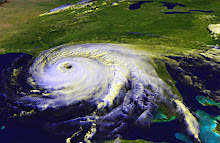
As of noon Friday, Ida is over land and down to tropical depression status. Soon, however, the system will move back over the water and head towards the Gulf of Mexico, where water temperatures are in the mid-80s, and warmer waters feed and strengthen tropical weather systems. Forecasters say Ida could reach hurricane strength again. The National Hurricane Center is anticipating that the storm will travel north for a bit and then turn east into Florida. Computer models are all over the place, with some moving the storm towards Texas or Louisiana, then possibly turn east. Others are following variations of the NHC's track (or rather, the NHC forecasters are putting more trust in those models that head east).
Fortunately, the waters near the coast of Florida are cooler than in the middle of the Gulf. That should help weaken Ida before she makes landfall.
Let's all keep an eye on this storm and be ready to take action to protect our homes and families if she heads our way.
Subscribe to:
Post Comments (Atom)
No comments:
Post a Comment