I guess we'll get to see if the National Hurricane Center is right about oil and hurricanes not mixing. Supposedly, the oil on the water will help keep the storm from absorbing water and the storm's activity may help disperse the oil faster. We'll see.
Soon.
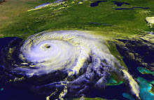
The NHC's track, as of July 22 at 11pm ET, shows Tropical Storm Bonnie striking Louisiana on Sunday evening. Forecasters say the storm's movement is being guided by a low pressure system on one side and a ridge on the other. Changes in those weather systems could change the storm's track. I'll be monitoring Bonnie until it makes landfall, as should anyone in Texas, Louisiana, Mississippi, Alabama and Florida.
Speaking of the Sunshine State, South Florida and the Keys can expect to feel Bonnie's effects on Friday. Forecasters expect the storm to pass directly over that area as it moves from the Atlantic into the Gulf.
The NHC is not predicting that Bonnie will reach hurricane strength before making final landfall, and that is a good thing.
Still, any bad storm can knock out power, even if it's just for a few hours. If it passes through my area, I will unplug my electronics (a power surge just blasted our desktop computer and it was plugged into a battery back-up surge protector, and the computer was off at the time). I have bottled water to last three days and several cans of tuna and chicken, so if the worst happens, we won't starve. We have working flashlights and batteries for the portable radio.
If you live in a coastal area, you could be hit by a tropical storm or hurricane. Hope for the best, but please be prepared for the worst.
Thursday, July 22, 2010
Subscribe to:
Comments (Atom)