The National Oceanic and Atmospheric Administration got the track of Hurricane Irene exactly right. Click on the link and watch the video. About 7 seconds in, the satellite image will pause for a second and you'll see the forecast track overlaid. Watch as the eye follows the track exactly.
NOAA Video
Hurricane forecasting is not an exact science, but I think this video shows that the NOAA and National Hurricane Center has developed a real knack for using their weather forecasting tools, historical evidence, and the various ensemble models from agencies and universities around the world to give us a forecast that gives people in the storm's path the best chance to prepare and protect their homes, businesses, and families.
Excellent work, NOAA!
Wednesday, August 31, 2011
Monday, August 29, 2011
Hurricane Aid: How Can I Help
First an earthquake, then a hurricane. The mid-Atlantic states were slammed in August 2011. If you’re not in that area, and you want to help those who are, here are some ways you can make a difference.
Help Someone You Know
Do you have friends or family in the affected area? Maybe a former co-worker has moved up there or someone you deal with for work is based there. Ask them how they are doing and what they need. Keep in mind that the mail may not run for a few days until roads are cleared of debris or flood waters recede, so it may be hard to meet immediate needs. Of course, if the person evacuated, depending on where they went, you can meet them or send them something to where they’re staying.
Work As a Group
Churches and civic organizations often travel to the affected area, taking supplies like water, non-perishable food, school supplies and clothing (for people who lost their homes). They may help people clean up their yards or repair damage. Sometimes, if they have a portable food trailer available or can arrange to use an available kitchen in the area, they prepare and serve meals, so people who live in the community have one less thing to worry about; they can just sit down and eat.
Give to Reputable Charities
The American Red Cross and Salvation Army will provide food, water and ice to people whose electricity is out or those living in shelters because their homes are flooded or destroyed. They also help people who lost everything get some clothing or shelter while they’re waiting for insurance payments (assuming they have insurance). Organizations like that have systems to help make sure the money gets to people who legitimately need it. Of course, someone’s always going to fool the system, and those are the ones you hear about, but these charities really do help those in need.
Don’t Forget the Animals
Many animals will end up in shelters because they got separated from their owners or maybe some didn’t have homes but they got picked up during the massive sweeps that will go through the hard-hit areas. You can send money to an animal charity, such as the Humane Society or ASPCA that serves one of the disaster areas. A lot of pet rescue organizations will also go into help rescue trapped, injured or traumatized animals, and they’ll need money to buy food, bottled water for the animals and their workers, and supplies to help clean up and treat the pets.
Beware of Scams
After a disaster, the con artists come out. You may see pleas for help on Facebook or online forums. Someone may come to your door and say they evacuated to your community from North Carolina and can you help them. Scammers will make phone calls to random numbers asking you to give money to help those in need. Be wary. Don’t give to someone who calls you on the phone. Don’t click on links in emails to “donate now.” It’s much better for you to look up the organization you want to give to and call them or find their website on your own to donate. Emails that may look like they’re coming from an legitimate organization can still be fakes.
Tuesday, August 23, 2011
Dangerous Even at a Distance
In August 2009, a few dozen people in New England went down to the shore to watch Hurricane Bill go by. The storm sent furious waves crashing onto the rocks, sweeping several people into the water. A seven-year-old girl drowned.
 This is Bill's track. You can get a closer look at the map at Unisys Weather. As you can see, the storm just barely brushed the U.S. coastline, but it was still violent enough to claim a child's life.
Please don't look at a dot on the map and think that because a hurricane is far out to see, that you're safe. Your safer than if it made landfall by your house. But even out to sea, a hurricane can still pack a deadly punch.
Be safe.
Please don't look at a dot on the map and think that because a hurricane is far out to see, that you're safe. Your safer than if it made landfall by your house. But even out to sea, a hurricane can still pack a deadly punch.
Be safe.
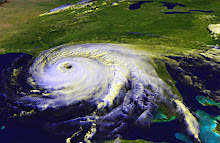
Rock Me Like a Hurricane
The U.S. Eastern Seaboard is getting slammed this week with double disasters. A 5.8 magnitude quake centered in Virginia shook the earth from Georgia to Canada on Tuesday, and Hurricane Irene is pelting the Bahamas with a triptych that takes the storm right along the U.S. coastline.
Even if Irene never makes landfall in the U.S., a powerful hurricane off shore -- even hundreds of miles off shore -- will have an impact on coastal communities. Hurricanes are often hundreds of miles across, so if the eye of the storm is 150 miles out to see, coastal areas could still get battered by high winds, drenched by rain, and flooded from storm surge.
If you live on the East Coast of the United States, I urge you to make sure you have bottled water and non-perishable food in your home in case of power outages. Check your first aid kit and make sure it's stocked with the essentials. Know where your insurance papers are. Pick up extra batteries for your radio and flashlights. Be aware if you're in a flood zone. Prepare your home by securing lawn furniture and moving anything inside that could become a missile in high winds. If advised, protect your windows with shutters, aluminum roofing sheets or plywood.
Watch the storm's progress on TV or use the National Hurricane Center website. Pay attention to any local advisories. Be safe.
The National Hurricane Center is watching two more areas of disturbed weather right behind Irene.
Wednesday, August 10, 2011
Disturbances in the Atlantic
Doesn't that title sound like a ghost story? Disturbances or low pressure systems or tropical waves are kind of ghostlike, at least from here on shore. I'm sure that if you were in the Atlantic, in the middle of one of those disturbances, it would be a pretty strong thunderstorm. Sitting comfortably on land, looking at the National Hurricane Center's Tropical Prediction page, they look like little blobby ghosts. Ephemeral things that may never develop into anything stronger than a thunderstorm.
A few years ago, the only things that showed up on the National Hurricane Center's website were tropical depressions and named storms. I think it was probably in response to people like me that they started including information about areas they were watching. You see, I'd go to the NHC to look for depressions or check on named storms, but then I'd hit Weather Underground or Crown Weather to see what else was on the horizon. This was after 2004 -- "summer of the storm" -- when Florida got hit by four named storms, and 2005 the year that we had so many storms -- including Katrina -- that we ran out of letters of the alphabet and started calling the named storms by Greek letters (Alpha, Beta, etc.).
 So now we have the blobs. Yellow blobs are areas that could develop but probably won't. Orange areas have a better than 30% chance of turning into a depression or worse. Red areas are very likely to become something stronger.
I look at this map and I see storms extending across the Florida peninsula. A good portion of the storm is over land, so it's not going to develop unless it moves out to sea. The NHC says it's moving east-northeast, so it'll go into the Atlantic and if it develops there, it probably won't cause much trouble for anyone. The yellow blob in the upper Atlantic won't develop; the waters are cooler up there. The orange blob -- there's a troublemaker. Unless there are wind shears or something to break it down, well, 'tis the season and the worst part of the season at that. It'll develop. It's little sister, tagging behind, will most likely develop, too.
I went over to Weather Underground, where sure enough they're showing computer models for those two blobs. That means the forecasters consider them a serious enough threat to consider potential tracks. Sometimes I hate being right.
Could they still break up? Absolutely. Look at Emily -- a full-fledged tropical storm, one day expected to become a hurricane, the next day fizzled out to nothing. Sometimes we get lucky.
All the hurricane forecasters were anticipating a "busier than usual" year, and we haven't had that much activity yet. Still, August through the first couple of weeks of October are typically the busiest times for hurricanes.
And that gives those of us on the coast plenty to be disturbed about.
A few years ago, the only things that showed up on the National Hurricane Center's website were tropical depressions and named storms. I think it was probably in response to people like me that they started including information about areas they were watching. You see, I'd go to the NHC to look for depressions or check on named storms, but then I'd hit Weather Underground or Crown Weather to see what else was on the horizon. This was after 2004 -- "summer of the storm" -- when Florida got hit by four named storms, and 2005 the year that we had so many storms -- including Katrina -- that we ran out of letters of the alphabet and started calling the named storms by Greek letters (Alpha, Beta, etc.).

I look at this map and I see storms extending across the Florida peninsula. A good portion of the storm is over land, so it's not going to develop unless it moves out to sea. The NHC says it's moving east-northeast, so it'll go into the Atlantic and if it develops there, it probably won't cause much trouble for anyone. The yellow blob in the upper Atlantic won't develop; the waters are cooler up there. The orange blob -- there's a troublemaker. Unless there are wind shears or something to break it down, well, 'tis the season and the worst part of the season at that. It'll develop. It's little sister, tagging behind, will most likely develop, too.
I went over to Weather Underground, where sure enough they're showing computer models for those two blobs. That means the forecasters consider them a serious enough threat to consider potential tracks. Sometimes I hate being right.
Could they still break up? Absolutely. Look at Emily -- a full-fledged tropical storm, one day expected to become a hurricane, the next day fizzled out to nothing. Sometimes we get lucky.
All the hurricane forecasters were anticipating a "busier than usual" year, and we haven't had that much activity yet. Still, August through the first couple of weeks of October are typically the busiest times for hurricanes.
And that gives those of us on the coast plenty to be disturbed about.
Monday, August 1, 2011
Tropical Storm Emily
Tropical Storm Emily started as a tropical wave in the southern Atlantic a few days ago. The National Hurricane Center is now tracking Emily, which is expected to hit several Caribbean islands before brushing against the east coast of Florida next weekend.
Of course, it's dangerous to look at the track now and assume that's where the storm is going.
The computer models have been steadily shifting west for the past few days, and if it shifts much more to the west, it'll come into the Gulf.
Looking at the national maps from the National Weather Service, an area of high pressure seems to be forming or moving across the Gulf and parts of the northern Gulf Coast. That could be what hurricane forecasters are looking at to keep the storm moving north in the Atlantic. Certainly if it shifts west and comes into the Gulf, that High could keep it to the eastern part of the Gulf.
If you live on a southeastern U.S. coastline, this storm bears watching.
Subscribe to:
Comments (Atom)