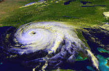
Hurricane Jimena is now a moderate Cat 3 hurricane, expected to make landfall late Wednesday or early Thursday. The storm is now moving north alongside the Baja peninsula, its powerful winds stretching over the narrow land mass to batter homes and businesses. A hurricane's strongest winds are typically east of the eye, and that's the part of Jimena that is stretched out over the Mexican peninsula. It's good news that the storm has weakened from a powerful Category 4 to a mid-range Cat 3. It's still a massive and terrible storm that will cause a lot of damage. By Sunday, the system is expected to degrade to a tropical low, which will certainly dump a lot of rain on the southern parts of California and Arizona.
With sustained winds of 50mph, the Atlantic's newest named storm is barely a Tropical Storm. The National Hurricane Center anticipates T.S. Erika to gain a little strength over the next couple of days as it moves west-northwest in the Atlantic, but forecasters believe a strengthening shear will then knock the wind out of Erika's sails. So to speak. The NHC's track keeps the storm east of Florida.
It's worth pointing out that a couple of the models, this according to the NHC, predict that an "anticyclone" will form near Erika and fuel the storm, maybe even taking it to hurricane strength. Out of six computer models mapped out on Weather Underground, three mimic the NHC's official track. The others keep the storm moving west towards the Caribbean.
Watch and wait.
Tuesday, September 1, 2009
Subscribe to:
Post Comments (Atom)

No comments:
Post a Comment