Saturday, August 25, 2012

Isaac Is Coming!

We put up some of our hurricane shutters today, on windows in the back of the house, the three pictured plus two smaller windows for the office and bathroom. Unless the track drastically changes, we'll put up most of the other ones tomorrow - side windows for office and bedroom, front windows on bedroom, cats' room, living room, dining room, and probably the back doors. I'm guessing Tim will want to wait and do the front door on Monday, so we can keep using it.

Once I get to work on Monday, I will likely be there until after the storm passes. I'll have the car, as our street will probably flood. With Ivan in 2004 and in the spring floods of 2005, the water got almost to our front porch, so the car will be safer in the parking lot at work. NOT under the tree where I usually park for shade.

I wasn't worried when Isaac was projected to be a Category 1 at landfall. Now it's expected to be a mid-range Cat 2. That's a little more troublesome, especially since we've had so much rain this year. Trees are blowing over left and right in regular thunderstorms. The large trees in our yard are all gone, but one neighbor has several oaks and pecans that could fall on our house, and another neighbor has a tall pine that could hit our shed.

If you want to better understand the Saffer-Simpson Scale (Cat 1-5), check out this animation created by The COMET Program and posted on the National Hurricane Center website. It illustrates how much wind damage can be caused at each level.

Be ready. Be safe.

Isaac on the Way

Isaac is intensifying as it approaches Haiti, and most of the models have it heading into the central Panhandle of Florida on Tuesday.

Ted Lange as Isaac Washington.
Am I the only one who keeps picturing Isaac from The Love Boat? I always liked Ted Lange. Unfortunately, the Isaac that's churning in the Gulf of Mexico is no fun to be around.

The models have been all over the place on this one. Over the past three days, the National Hurricane Center's track has taken the storm as far west as Mississippi and as far east as the Florida Peninsula. Sometimes the models are close together, sometimes they're more spread out.

A lot of different factors go into determining the way the storm will go. Troughs, ridges, high pressure systems all play a role in guiding the storm, and different models predict different developments of those areas. In other words, it's a guessing game. A very scientific guessing game based on our knowledge of weather patterns over the years, but it's guessing all the same.

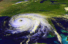
No matter where the eye makes landfall, the rest of the Gulf Coast will get some of its effects. Right now, the storm is about 460 miles across. It's getting smaller; on Thursday, I read it was 678 miles across and before that, I'd heard a thousand miles across. Tropical cyclones tend to get smaller as they become more organized, as Isaac is doing now. It was a very scattered, low intensity storm. As I write this at 2:30 a.m. on Saturday, the eye is becoming more defined. It makes a pretty picture, but it means the storm is getting scarier.

I bought batteries, duct tape, wet wipes, extra bandage strips, bread, and lots of bottled water today. We have plenty of canned tuna and chicken, potted meat, Vienna sausages, and green beans (which we eat cold out of the can). I also picked up some BelVita Breakfast Biscuits; they're like cookies but with some nutritious value. We have some shelf stable milk in the fridge, but I need to drink up the half gallon of soy milk I bought last week. Maybe that's what doomed us; since Hurricane Ivan, we haven't bought two gallons of milk at the same time, but this is soy AND it's chocolate, so I didn't think it would count. Yes, I'm a bit superstitious about this!

We'll continue to watch the storm's track and decide on Sunday if we need to put up the storm shutters that we got through Rebuild Northwest Florida. I'm glad that we'll be able to cover all of our windows this time; the long windows on the two front bedrooms didn't have any protection before, and all we had over the three large windows on the back room were burglar bars. Our roof was replaced, and between the roofing company and the folks from Rebuild, we have lots of extra nails and tie-downs in, to keep it attached.

I think we're as prepared as we can be.

My worries: one of the neighbors' trees has been leaning a bit since Ivan; the ground is saturated because of the flood event on June 9 and near daily storms since; and one of the cats is sick, which is unrelated to the storm of course, but still an extra stress we don't need. We will have to try to fix up some new sandbags this weekend.

Are you ready for the storm? Do you have a Family Disaster Plan and a well-stocked Disaster Kit? If you live on the Gulf Coast, you should have one ready. If Isaac doesn't come your way, the next storm might.

Friday, August 24, 2012

Tips for Safe Homes

The Federal Alliance for Safe Homes® offers tips and resources for families preparing in advance of Tropical Storm Isaac. Resources include emergency plywood shutter installation, evacuation tips and items for hurricane emergency kits.

As Tropical Storm Isaac moves west, the Federal Alliance for Safe Homes (FLASH)® encourages families to take steps now to properly prepare themselves and their homes for severe conditions. 

"As this storm approaches, families may be tempted to take out a roll of tape for the windows but taping offers no protection against tropical storm or hurricane damage," says Leslie Chapman-Henderson, President/CEO of FLASH. "Right now, families can follow the guidelines in our Protect Your Home in a FLASH toolkit to learn the correct ways to prepare for a hurricane. These free resources can help them get ready for Isaac or whatever else may come this hurricane season."

FLASH recommends these preparedness tips for families in the path of Tropical Storm Isaac:

Protect Your Home

  • If you have hurricane shutters now is the time to install them. Make sure your shutters are working properly and fit securely to ensure proper protection.
  • If you don't have shutters, install plywood, emergency shutters. Never use tape on windows as hurricane protection. 
  • Secure or relocate items outside the house that can blow around. Don't forget about trash cans, grills, toys and potted plants. Also, take time to look for any dead tree limbs and remove them carefully if you have time.
Have an evacuation plan for your home. Before you leave be sure to:
  • Turn off the water, gas and electricity  
  • Leave a note that you have left and where you are going
  • Be sure to lock your home
Prepare Your Family
  • Review your family emergency plan. Be sure to review and update any evacuation plans.
  • Ensure your family emergency kit is complete. Your kit should include, at a minimum:
             o Enough food and water for all members
                of the family, including pets, to last at
                least 72 hours
             o Extra cash on hand since an extended power 
                outage may prevent you from withdrawing
                money from ATM's or banks
             o A battery powered and NOAA weather radio 
             o First aid kit and toiletries
             o Flashlights and extra batteries
             o Blankets, pillows, extra clothes, toys and games
                to keep the family comfortable and occupied
             o Special needs items for babies, family members with special medical needs and pets
  • Fill your gas tank; gas stations rely on electricity to power their pumps.
  • Gather and store important paperwork like insurance papers, mortgage documents, marriage certificates, etc. in waterproof containers.

If the Power Goes Out
  • Do not run a generator inside a home or garage. Use gas-powered generators only in well-ventilated areas.
  • Connect only individual appliances to portable generators.
  • Don't plug emergency generators into electric outlets or hook them directly to your home's electrical system - as they can feed electricity back into the power lines, putting you and line workers in danger.
  • When power comes back on, it may come back with momentary, "surges" or "spikes" that can damage equipment such as computers and motors in appliances like the air conditioner, refrigerator, washer or furnace.
  • When power is restored, wait a few minutes before turning on major appliances to help eliminate further problems caused by a sharp increase in demand.
This is a press release prepared by FLASH. For more hurricane preparedness tips visit www.flash.org or call 877-221-SAFE.

Wednesday, August 1, 2012

The Tropics Heat Up

Tropical depression five is headed towards the Caribbean, and forecasters expect it to reach hurricane strength by Monday. It's expected to pass between Puerto Rico and Venezuela, so all those little islands down there are in the path as it makes a beeline for Jamaica. If it does continue to strengthen as expected, its name will be Ernesto.

If you live on the Gulf Coast, this is the time to look over your hurricane checklists and start doing some preliminary planning. Here's a simple page with a few things to think about, from the Baldwin County, Alabama, Electric Membership Corporation.