I'm a little mystified by the Royal Gazette's coverage of Hurricane Bill. First of all, I went to the Bermuda's paper's website and it was the fourth item down. Top story (breaking news) was some sports story.
Then I read the article. They quote a Bermuda Weather Service forecaster as saying, "It is a long way away. If it does come up towards Bermuda, the forecast says that it will pass to the west of the Island."
Hurricane Ike passed about 350 miles south of Pensacola, and we had flooding from some storm surge. (I arrived at that 350 miles figure by looking at the storm's path. Pensacola is on the 30 latitude line and the storm passed on the 25 latitude line. One latitude line is about 70 miles, so by my calculations 5 latitude lines=350 miles.)
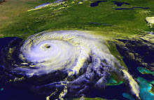
Looking at the satellite photos of Bill, if the storm's eye passes about 100 miles from Bermuda (as the aforementioned forecaster suggested), it's still going to be a nasty hit to the island. A hurricane is not a dot on a map. That's just the eye. Yes, the winds are usually worst right around the eye, but there's a lot of destructive power spread out over hundreds of miles. As well, the forecast has Bill tracking west of the island. You never want to be on the east side of a hurricane, at least not in the northern hemisphere.
In 2005, Katrina made landfall on the Mississippi Gulf Coast, about 152 miles west of Pensacola, and my power was out for three days. Not that I'm complaining, I'm just demonstrating that the reach of a major hurricane goes well beyond that little dot on the map.
I hope that the people of Bermuda are taking this more seriously than their newspaper seems to be and that they're stocking up and making plans to take themselves and their pets to the highest ground they can find.
I'll give the paper some points for including a checklist of supplies to buy and steps to take in advance of the storm, but they don't really seem to be stressing that the time to take action is now.
Subscribe to:
Post Comments (Atom)
No comments:
Post a Comment