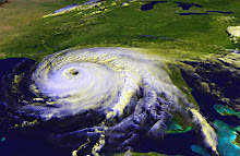
According to the latest advisory from the National Hurricane Center, Hurricane Bill is about 510 miles across. Hurricane force winds extend out 105 miles from the eye (that's one way). Tropical storm force winds will be felt up to 260 miles from the center. Sustained winds are currently 125 miles per hour, a strong Category 3 storm. It's good that the winds have fallen down a bit, although the NHC advisory says the storm could pick up strength again on Friday. The U.S. east coast and Bermuda will experience storm surge, and will very likely feel a lot of wind and rain.
The latest track seems to have Bill passing a bit further west of Bermuda than it showed earlier in the week. Of course, there's always a margin of error, hence the "cone of uncertainty" that appears around the forecast track on most maps.
If you're interested in reviewing the accuracy or inaccuracy of the National Hurricane Center's forecasts, here's a great place to go: the Graphics Archive. That link will take you to a list of choices. I like to use the 5-day forecast with cone of uncertainty. When you click on the link, you'll get a slideshow of all the forecast maps since the NHC has been tracking the storm. You can use the controls at left to STOP the automatic loop, then use the little arrow buttons to toggle one frame at a time. This is good because the size of the map changes sometimes, resulting in a kind of jump cut that can be disorienting.
It's very interesting to see how the storm's track changes while still generally staying within the "cone of uncertainty."
Otherwise, the tropics remain calm, after a somewhat surprising burst of activity over the past week.
I wish everyone well who's anywhere near the path of Hurricane Bill.
Subscribe to:
Post Comments (Atom)
No comments:
Post a Comment