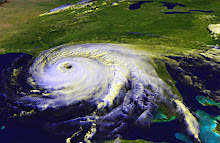
Hurricane Ida is a Category 2 storm expected to make landfall in Pensacola or thereabouts early on Tuesday. The Pensacola News Journal has some updates on school closings. If you read the comments on the PNJ's website, you'll get the impression that the locals aren't taking this seriously, except as an excuse to get out of going to work or school.
We were gone to an event all day today, so we really haven't done any preparations. Depending on the latest track on Monday afternoon, we may cover our large living room window after work. At this point, the storm is expected to lose quite a bit of steam before making landfall, in large part because of cooler water temps near the coast. We did buy some extra water on Saturday, we have our supply of GoPicnic meals, as well as peanut butter and canned tuna, so we'll be okay. If we should lose power for more than a day, we can drag out the generator (and hope we can get some gas to go in it). However, I'm not anticipating more than a few hours without power, if we lose it at all.
The most important thing will be to take a look around your home, keeping an eye out for anything that can be caught in the wind: loose limbs that could be trimmed before the storm gets here, a piece of shingle or loose gutter that could be tacked down befor the wind tears it away. Pick up toys, put up patio furniture. Anything that can be blown around by a strong gust of wind can become a missile that breaks windows, dents cars, and causes other damage.
It's great that people aren't panicking about Ida, but nor should they (or you, if you're in the path) believe that this storm will not be capable of damage. Any tropical storm has the ability to cause wind damage and flooding. Be proactive for the safety of your home and family and for the people around you.
Subscribe to:
Post Comments (Atom)
No comments:
Post a Comment