Bands of rain have been passing over the area off and on all day as Ida moved closer to the Northwest Florida coast. The wind is starting to gust now. Tim put up the small yard waste cans; the large garbage cans ought to be all right. The regular trash has some big bags of cat litter in it which should help hold it down. In addition, we piled in some small limbs that had been sitting in the back yard for a while. Our workplaces both shut down early today, which gave us a chance to get those last minute preps done while we still had daylight.
I'm charging my cell phone, and I really ought not to be running the laptop off battery, but it's easier, and I don't expect to lose power. I'll plug it in later to top off the charge, then unplug it when things get bad to protect against surges.
Today, the National Hurricane Center has taken the line off the graphic showing the projected path. Perhaps too many people are focusing on that line and not on the fact that this is a large storm with tropical storm force winds extending 200 miles from the center. That means, the storm is 400 miles across, and even if you're on the very edge of the storm, you will experience sustained winds of 38mph or more.
Ida will not, for most people, be catastrophic, however, hurricanes and tropical storms can spin off tornados. Sustained high winds over several hours can break a weak limb, pull up a loose shingle, and cause other damage. Nothing to worry about unless it's your house that suddenly springs a leak or your car that has a broken windshield from a broken branch.
Now, while tropical storms and National Hurricane Advisories are on everyone's mind, the NHC is looking for input about how their public advisories are presented. Take a moment and go to the NHC's discussion page. They present several examples of public advisories prepared in the current style and the proposed new style. Compare them, then drop the NHC a note letting them know what you like and don't like. This will determine how information is presented in the future.
Monday, November 9, 2009
Sunday, November 8, 2009
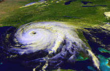
Ida makes beeline for Northwest Florida
Hurricane Ida is a Category 2 storm expected to make landfall in Pensacola or thereabouts early on Tuesday. The Pensacola News Journal has some updates on school closings. If you read the comments on the PNJ's website, you'll get the impression that the locals aren't taking this seriously, except as an excuse to get out of going to work or school.
We were gone to an event all day today, so we really haven't done any preparations. Depending on the latest track on Monday afternoon, we may cover our large living room window after work. At this point, the storm is expected to lose quite a bit of steam before making landfall, in large part because of cooler water temps near the coast. We did buy some extra water on Saturday, we have our supply of GoPicnic meals, as well as peanut butter and canned tuna, so we'll be okay. If we should lose power for more than a day, we can drag out the generator (and hope we can get some gas to go in it). However, I'm not anticipating more than a few hours without power, if we lose it at all.
The most important thing will be to take a look around your home, keeping an eye out for anything that can be caught in the wind: loose limbs that could be trimmed before the storm gets here, a piece of shingle or loose gutter that could be tacked down befor the wind tears it away. Pick up toys, put up patio furniture. Anything that can be blown around by a strong gust of wind can become a missile that breaks windows, dents cars, and causes other damage.
It's great that people aren't panicking about Ida, but nor should they (or you, if you're in the path) believe that this storm will not be capable of damage. Any tropical storm has the ability to cause wind damage and flooding. Be proactive for the safety of your home and family and for the people around you.
Saturday, November 7, 2009
Ida is a tropical storm again.
The Florida panhandle is definitely going to feel some effects from Tropical Storm Ida in a couple of days. All the computer models show it crossing or at least coming near Northwest Florida. The official track is pointing it a bit more towards Panama City, but of course, areas to the west and east are still in the cone of uncertainty. Also, the storm's wind and rain will extend far beyond a single point on the map. Folks in low lying areas should prepare for storm surge as well. Even if Ida is "only" a tropical storm, it could still cause flooding from rising waters as well as rainfall. It's probably a good idea to secure anything that can blow around. We don't know what kind of winds we'll feel, and it's better to be safe than sorry.
Friday, November 6, 2009
Ida expected to re-strengthen
As of noon Friday, Ida is over land and down to tropical depression status. Soon, however, the system will move back over the water and head towards the Gulf of Mexico, where water temperatures are in the mid-80s, and warmer waters feed and strengthen tropical weather systems. Forecasters say Ida could reach hurricane strength again. The National Hurricane Center is anticipating that the storm will travel north for a bit and then turn east into Florida. Computer models are all over the place, with some moving the storm towards Texas or Louisiana, then possibly turn east. Others are following variations of the NHC's track (or rather, the NHC forecasters are putting more trust in those models that head east).
Fortunately, the waters near the coast of Florida are cooler than in the middle of the Gulf. That should help weaken Ida before she makes landfall.
Let's all keep an eye on this storm and be ready to take action to protect our homes and families if she heads our way.
Fortunately, the waters near the coast of Florida are cooler than in the middle of the Gulf. That should help weaken Ida before she makes landfall.
Let's all keep an eye on this storm and be ready to take action to protect our homes and families if she heads our way.
Thursday, November 5, 2009
A Hurricane in Novemberr?!
Hurricane Ida is now swirling in the waters off Nicaragua. That's right, a full-fledged Category 1 hurricane has formed in November.
Hurricane season ends November 30, and it's not unprecedented to see tropical storms and hurricanes this late in the year. A couple of times in recent memory, we've even had named storms develop in December. Aren't those pesky storms watching the calendar?
The National Hurricane Center has the storm crossing Nicaragua and Honduras, losing strength over land, then moving back over the open water, strengthening to tropical storm status and heading into the Gulf.
The good news is, the waters are cooling, so the storm shouldn't gain a lot of strength. It still has the potential to cause some wind damage and flooding upon landfall.
The ensemble models are all over the place, but at this point, if you live on the Gulf Coast, you should begin watching the National Hurricane Center for updates. I'll be checking my stock of canned goods, and I just received a package of six GoPicnic meals through an online giveaway. If the storm hits Pensacola and power gets knocked out, I'll be okay until they get it turned back on. I don't expect this to be a two-weeks-without-power experience, just a couple or three days at most.
At this point in the season, I'm a little calmer, because I don't expect a monster storm. Please, Mother Nature, don't prove me wrong! If you live in an area that could be targeted by Ida, do what I'm doing and watch the track, check for a few supplies, and don't stock up on refrigerated foods.
Subscribe to:
Comments (Atom)