On days like today, when there are low pressure systems that could develop into a cyclonic system, I'll follow up with a visit to Weather Underground. The more "serious" low pressure systems will be tracked by various forecasting centers, and the computer models will give you an idea of where that system will end up - whether it develops or not.

What's the difference between the spaghetti models and the ensemble and the "official" track from the NHC?
The development and movement of a tropical system, or really any storm system, is dependent on a lot of different factors. High and low pressure systems, for example, affect how the storms move. Wind shear may weaken a storm. Warm waters strengthen them. Scientists have been studying hurricanes for years, so they know how all these different atmospheric and oceanic conditions may change the storm.
Once computers came along, they created software that lets them plug in all this data, and then the software analyzes it and says, "This is where the storm could be going and how strong it's likely to get on the way."
The differences in the models come from how the the software applies the knowledge. In one case, the software may not consider the movement of warm and cold ocean currents. Another program may give more weight to those same currents and place a lower priority on wind shear.

Let's say that you wanted to determine the likelihood that someone can blow out all the candles on his/her birthday cake. The first thing you would do, if you were a forecaster, would be to collect information about past parties. Maybe you find some anecdotal evidence in old diaries ("Aunt Marge took a mighty break - she was a trained opera singer in her youth, after all - and with a great gust, she blew out all 40 of the candles on her cake."). You study birthday videos on YouTube and analyze the age, apparent lungworthiness, number of candles, and angle of approach. You take into consideration the presence of ceiling fans, air vents, and fireplaces. You pay poor college students a dollar a puff to blow out various types of candles in slightly different configurations on simulated cakes in common and unusual settings. You program your computer with all the data. Then, when Sissy's 16th birthday roles around, you plug in her age, the seriousness of her asthma, the brand of candles, the dimensions of the room, and the number of guests. You give it your best guess as to whether her birthday wish will come true.
Then you watch and see what really happens.
Weather forecasting is a guessing game.
To be sure, the guesses are very well educated, and forecasting has come a long way even in the past dozen years. The tools used to collect data are extremely sophisticated, and meteorologists have had a lot of storms to watch and study - 27 systems in 2005 alone. It will never be an exact science, because one little change in a weather system over the Rockies can ricochet down to the Gulf and slow a storm down or cause it to turn.
Why bother?
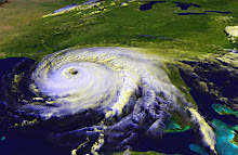
When a storm forms in the Atlantic off the coast of Africa, and we look at that photo of clouds over the ocean, we can't tell from that snapshot whether it's going to slam into the Gulf Coast of Florida in three weeks (Ivan, 2004) or if it's going to spin off harmlessly into the North Atlantic and dissipate in a week (Karl, 2004) or if it's going to lay waste to the Carolina coast two weeks later (Hugo, 1989). The computer models help narrow down which way the storm is going, giving those of us who live on a coastline advance warning, time to fill up the gas cans, buy extra (non-perishable) groceries, cook up the food in the freezer, and pack a bag (if you have to evacuate).
In an uncertain world, a little extra time to prepare is the best we can hope for.
No comments:
Post a Comment