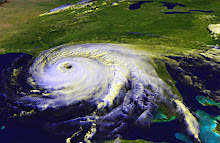
The National Oceanic and Atmospheric Administration got the track of Hurricane Irene exactly right. Click on the link and watch the video. About 7 seconds in, the satellite image will pause for a second and you'll see the forecast track overlaid. Watch as the eye follows the track exactly.
NOAA Video
Hurricane forecasting is not an exact science, but I think this video shows that the NOAA and National Hurricane Center has developed a real knack for using their weather forecasting tools, historical evidence, and the various ensemble models from agencies and universities around the world to give us a forecast that gives people in the storm's path the best chance to prepare and protect their homes, businesses, and families.
Excellent work, NOAA!
Subscribe to:
Post Comments (Atom)
No comments:
Post a Comment