Tuesday, February 8, 2011

Category 5 Yasi

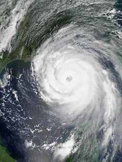
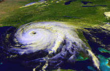
The ratings scale that classifies tropical cyclones goes from 1 to 5, with 5 being the most destructive. It was a category 5 storm, with wind gusting up to 180 miles per hour, that slammed into Australia on February 3, 2011. Yasi was the largest and most powerful cyclone to hit that nation in at least a hundred years. Once over land, the storm began to weaken, but after traveling around 250 miles inland, Yasi was still a category 3. After another 250 miles, the storm finally began to fade. Yet for all its destruction, at this point Yasi is blamed for only one death. It's one of those really tragic, preventable deaths. A 23-year-old man died of carbon monoxide poisoning while running a generator in a closed room. Emergency Services Minister Neil Roberts gave credit for the low death toll to Australians who prepared early and evacuated coastal areas and flood zones. It's worth comparing this Australian storm to Hurricane Katrina, which devastated coastal Mississippi and Louisiana in 2005. The storms were very similar in size and strength, but Katrina is blamed for the deaths of more than 1,800 people.
Yasi 2011
Katrina 2005
YASI - 2011 KATRINA - 2005
Sustained Winds 155mph Sustained Winds 175mph
Low Pressure 929mbars Low Pressure 902mbars
Size: 372 miles across Size: 397 miles across
The impact of a hurricane or cyclone depends on many factors beyond the size of the storm and its wind speed. How fast the storm crosses the area, whether it makes landfall at high tide or low tide, the geography of the region will all affect how much damage is done. When you find yourself in the path of the storm, you need to be prepared for the worst. In Australia, residents were warned that response would take at least 24 hours. U.S. and state emergency management officials encourage everyone to be able to take care of themselves for the first 72 hours. That means:
  • non-perishable food for three days (9 meals plus snacks)
  • water for three days (1 gallon per person per day)
  • first aid kit with bandages, antiseptic treatments, painkillers and any needed prescription drugs
  • battery powered, solar-powered or dynamo-powered radio for news and information
  • battery powered, solar-powered or dynamo-powered flashlights
  • food and water for pets
  • supplies to care for infants, children and the elderly as needed
Thousands of people in Australia are still without power. Homes and livelihoods are destroyed. This is all happening in a regional already devastated by deadly flooding this season. Disaster can strike anywhere, at any time. Think about your family's disaster plan now and prepare for the future.

Friday, December 31, 2010

Weather and Fire Safety

Weather conditions are a big factor in the risk of wildfire. A good, steady rain soaks into the ground and vegetation. Grass and trees in the ground have plenty to drink, so the stems and trunks are full of water. A stray cigarette butt or lightning strike is less likely to spark a fire. 

When it's very dry, grass and trees dry out, too. They get brittle, and any stray bit of ash can ignite a fire that will spread quickly through wooded areas. A lot of wind is also bad news. Have you ever blown on a burning cinder and watched it glow brighter or even flare up? If a breeze hits ash from a campfire or a hot spot from lightning just right, it can keep it burning and ignite dry materials nearby. 

Wind also spreads fire. It pushes the flames across fields. It picks up burning ash and debris and carries it to new areas. That's one way that fire can cross a road or ditch that would normally act as a barrier. 

The National Weather Service has a page on Fire Weather Conditions. Your state's Forestry Service or Fire Marshall's office website may also have information on fire dangers. Before you set off fireworks, burn trash and debris, or start a campfire, check the conditions and make sure it's safe. Check with your local fire department about burn permits. When you are putting out a fire on the ground, stir up the ashes; even if you douse the area with water, hot spots can remain deep inside the ash for days. Those hot spots can reignite and if the fire grows and spreads, it could put homes, human lives, wildlife and firefighters at risk.

Friday, December 3, 2010

Off-Season Safety - Surviving the Holidays

I turned on the radio last night to listen to the news, and I heard a horrible story. A mother and adult son died in their home because of a fire that is still under investigation, but friends say that space heaters used in the home were probably to blame. The family dog probably perished as well. 

Right after that story, they reported on another house fire where thankfully, no one was hurt, but the home sustained major fire, smoke and water damage. That one was caused by ash or debris flying out of the fireplace, alighting combustible material nearby. 

When I started looking for the details on those two fires, I found a report of another blaze that destroyed a home this morning. The cause is under investigation, but the fire chief believes space heaters are to blame. No one was physically hurt, but the residents are homeless now. 

That article contained information on another situation where the house didn't burn, but smoke was backing up in the home because the fireplace flue wasn't opened correctly -- a fire waiting to happen, and certainly if the people who lived there had been asleep with no working alarm, they could have perished from the smoke. All this reminds of a story from a few years ago, when a woman and her daughter died in a fire. They were on disability, as I recall, and they didn't have electricity in their home. We were in a really cold snap, as we are this week, and they were trying to stay warm by burning a fire in a metal drum. This is always the most dangerous time of year for house fires in Northwest Florida. We're experiencing the first sustained cold temperatures of the year, and in addition to trying to stay warm, people are distracted with the holidays, they're cooking more, they're adding Christmas trees and holiday lights into the mix, and the risk shoots up. 

Here are my safety tips, which I have learned from years in the news business. 

The space in "space heater" is the space you need to leave around it. Many fires begin when a heater gets tipped over (newer ones will automatically shut off when knocked over). Other fires start because a blanket or clothes or anything flammable ends up on top of the heater. Make sure your space heater is in a clear area, and check it frequently to make sure a child, pet or the wind doesn't create a fire hazard by putting something flammable near or on the heater. 

If you must burn a fire: be sure that your chimney is clean, the flue is functioning correctly and it's open, you have clear space in front of the fireplace, and you have a good fireplace screen to catch ash that might flight out. Please, never burn a fire indoors in anything other than a fireplace or properly installed wood-burning stove. Properly installed means it has venting to take the smoke outside. A smoky room can kill you, too, plus if it's not venting out, that means the risk of hot ash is higher in the house as well. 

Have your heating system serviced and cleaned annually. Carbon monoxide is the silent killer. Whole families die in their sleep from dirty heating systems or leaks. 

Read the labels on electronics, appliances and holiday lights. Make sure you're not overloading your outlets. Use surge protectors. Make sure cords are out of the way. Check once in a while to make sure the cords, outlets, and power strips aren't hot to the touch. Major open flame fire hazard: blowing curtains. When you're lighting candles or building a fire, take a moment to step back and survey the surroundings with an eye to safety. Is there anything flammable nearby? Are there papers, lightweight materials or toys that could get blown or knocked into the flames? Never, ever leave the house with a fire burning or candles lit. 

 Here are some more links to fire safety tips:  

Underwriters Laboratories: Top 10 Tips for Safer Holidays  

Underwriters Laboratories: Christmas Tree Fire Video - It only takes a minute  

National Fire Protection Association: Put a Freeze on Winter Fires  

U.S. Fire Administration: Holiday Fire Safety 

My tips are mostly on preventing fires. If the worst happens, are you prepared? Do you have: working smoke detectors? a family escape plan? copies of important documents, such as identification and insurance records, off site? Thinking about what you would do -- how you would get out, how you'd make sure your family members are all safe and accounted for -- will ease your mind in the event of an emergency. It's easier said than done sometimes, but most possessions can be replaced. Sure, if your house burns, you may lose precious mementos, but as hard as they are to lose, they are just things. The truly important thing is that your family members get out alive. 

Underwriters Laboratories is running a promotion with several bloggers right now. I am not one of those bloggers. I receive no compensation from anyone for any part of this post. I only mention it because I did learn about UL's online fire safety tips through one of these blogs, and I don't want there to be any confusion. Stay safe.

Wednesday, November 17, 2010

Almost over for another year

The 2010 hurricane is almost over, at least as far as the official dates go. Every now and then we'll see a December storm or even one in January. They're usually Atlantic storms that don't come close to land. 

This year's season wasn't quite a record-breaker. From Alex in June to Tomas, which kicked up in October and fizzled out ten days ago, we saw a total of 19 named storms. Twelve of those storms were hurricanes, and five reached major hurricane strength (category 3 or higher). 2010 is (tied with 1995 and 1887) the third busiest hurricane season in the past 160 years. 

The busiest, well I don't need to look that one up. It was 2005, the year that Dennis and Katrina hit my area. That season brought 27 named storms - and four of them blew up between November 18 and January 6, 2006. What was I just saying about post-season storms? 

I read one article that stated that none of the storms this season hit the United States. While technically true -- none of the storms made landfall on a U.S. coastline -- the storms did impact the United States. Hermine made landfall in Mexico but quickly moved into Texas. Several storms passed close by and/or dissipated right off the Gulf Coast or Eastern Seaboard. Storms in the Gulf put the BP oil spill clean-up on hold a couple of times. 

I'm not saying that we weren't lucky. We were very lucky. It seems impossible that in a year with 19 named storms, the U.S. didn't get hit. Not that I'm complaining! If you'd like to review the 2010 season and learn more about the storms and statistics of 2010, visit Wikipedia. For historical data on storms going back over a hundred years, check out Unisys Weather.* Now, time to start moving those canned goods out of the emergency kit and using them for winter meals.

*UPDATE Unisys changed hands, and the historical hurricane data has been removed from their website. 

Friday, September 17, 2010

Be Aware and Prepared

If you live in a coastal community, it's your responsibility to know what's happening in the tropics between June 1 and November 30, the official dates of hurricane season. 

Of course, hurricanes don't have calendars and can occur at any time of year, but the worst ones typically happen during these months. 

The reason I bring this up is that while the American media tends to overhype everything, other interests in the Atlantic and Gulf regions may not. 

Consider this: On September 12, after looking at the National Hurricane Center's track (right) and the computer models for Hurricane Igor, I visited the website for The Royal Gazette, the newspaper for Bermuda. I found no mention of Igor, though the paper does maintain an online "Hurricane Awareness" section. I tweeted my surprise: It always amazes me that Bermuda's Royal Gazette doesn't carry advance information on hurricanes that will pass close to or hit the island. 

7:33 PM Sep 12th via web I received this response: "We do, but unless it is going to be a direct threat, it does not much of a story" 

Two or three days later, I didn't note the date, one article about Igor did appear in the online edition. The tone was, to my mind, very non-committal, like the Weather Service and/or the reporter were reluctant to get anyone overly excited, in case the storm didn't affect the island. Saturday, the front page is full of reports about Igor. The storm's outer bands have already reached Bermuda, with the eye expected to pass very close to the island on Sunday evening.

The Royal Gazette's handling of the Igor story is the opposite of how U.S. mainstream media operates. The Weather Channel, cable news, and local news outlets focus so much attention on a potential disaster, that viewers get sick of hearing about it or begin disbelieving the "hype." I don't know if it's because I worked in the news business for seven years or because I've been through a major hurricane or both, but hype or not, I'd rather have as much advance notice as possible. What about you?

Monday, August 30, 2010

Earl is on the Way

If you live in North Carolina or Virginia, there's a good chance you're going to feel the force of Earl later this week. Earl is presently a Category 4 hurricane with sustained winds of 135 miles per hour and higher gusts. The storm is over 400 miles wide!

Even if the eye of the storm stays off shore, hurricane force winds (sustained winds of 70mph or higher) extend outward from the eye up to 70 miles. Tropical storm force winds (39mph or higher) extend up to 200 miles from the eye.

The current track, always subject to change by a few degrees, brings the eye fairly close to the North Carolina coast. East coast residents should expect wind, rain, storm surge, and flooding. Be prepared for power outages. Pick up potential flying objects from your yard. Keep a close eye on the forecast tracks in case anything changes.

Be safe.

Sunday, August 29, 2010

Earl Moves West, Where Next?

Earl is a little more south and west today than the National Hurricane Center was predicting on Thursday. That the track is as accurate as it is, is a testament to the knowledge that forecasters have about how storms move and to the computer tools that crunch the data. They're doing a marvelous job.

However, weather forecasting is a system of educated guesses. The fact that the track was a little off is to be expected. That's why they have that big cone of uncertainty around the track. One little wobble, one slight deviation can send the storm hundreds of miles in a different direction.

If you live in the Caribbean Islands you should be ready to feel the storm's effects, and as Earl makes up his mind which way he's going next, I encourage anyone living on the Eastern Seaboard, particularly in the Carolinas or Virginia, to make preliminary preparations for Earl's passing.

Hopefully, you already did some prep work for Danielle and breathed a big sigh of relief when she stayed well east of U.S. shores. Think about the two or three days notice you might get if Earl ends up coming your way. What will you need to do during that time? What can you do now to save yourself time if the hurricane comes your way?

Many of my earlier posts on this blog offer suggestions for things to think about ahead of a natural disaster. You can also visit the links on my sidebar for checklists and tips for preparation.

Here are some ideas:

Before the storm:
Prepare your property for high winds and heavy rains.
Know if you need to evacuate or sandbag your home.
Be ready to prepare meals without electricity or running water.
Care for your family's health, and that includes the family pets.

After the storm:
Make temporary repairs.
File insurance claims.
Notify friends, family and co-workers of your situation.
Will you have to report for work? Or will you be living without a paycheck?

Please don't wait until the last minute to think things through.
You'll need to remain calm and take quick action if the storm turns your way.
Advance planning is the key.