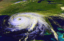
Doesn't that title sound like a ghost story? Disturbances or low pressure systems or tropical waves are kind of ghostlike, at least from here on shore. I'm sure that if you were in the Atlantic, in the middle of one of those disturbances, it would be a pretty strong thunderstorm. Sitting comfortably on land, looking at the National Hurricane Center's Tropical Prediction page, they look like little blobby ghosts. Ephemeral things that may never develop into anything stronger than a thunderstorm.
A few years ago, the only things that showed up on the National Hurricane Center's website were tropical depressions and named storms. I think it was probably in response to people like me that they started including information about areas they were watching. You see, I'd go to the NHC to look for depressions or check on named storms, but then I'd hit Weather Underground or Crown Weather to see what else was on the horizon. This was after 2004 -- "summer of the storm" -- when Florida got hit by four named storms, and 2005 the year that we had so many storms -- including Katrina -- that we ran out of letters of the alphabet and started calling the named storms by Greek letters (Alpha, Beta, etc.).
So now we have the blobs. Yellow blobs are areas that could develop but probably won't. Orange areas have a better than 30% chance of turning into a depression or worse. Red areas are very likely to become something stronger.
I look at this map and I see storms extending across the Florida peninsula. A good portion of the storm is over land, so it's not going to develop unless it moves out to sea. The NHC says it's moving east-northeast, so it'll go into the Atlantic and if it develops there, it probably won't cause much trouble for anyone. The yellow blob in the upper Atlantic won't develop; the waters are cooler up there. The orange blob -- there's a troublemaker. Unless there are wind shears or something to break it down, well, 'tis the season and the worst part of the season at that. It'll develop. It's little sister, tagging behind, will most likely develop, too.
I went over to Weather Underground, where sure enough they're showing computer models for those two blobs. That means the forecasters consider them a serious enough threat to consider potential tracks. Sometimes I hate being right.
Could they still break up? Absolutely. Look at Emily -- a full-fledged tropical storm, one day expected to become a hurricane, the next day fizzled out to nothing. Sometimes we get lucky.
All the hurricane forecasters were anticipating a "busier than usual" year, and we haven't had that much activity yet. Still, August through the first couple of weeks of October are typically the busiest times for hurricanes.
And that gives those of us on the coast plenty to be disturbed about.
Wednesday, August 10, 2011
Subscribe to:
Post Comments (Atom)


No comments:
Post a Comment