Showing posts with label hurricanes. Show all posts

Wednesday, July 14, 2021

Rapid Intensification

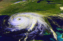
In recent years, we've seen several storms coming up through the Gulf of Mexico that were not forecast to become major hurricanes until just hours before landfall.

Hurricane Michael in 2018, for example. A couple of days out, it was expected to be a Category 2, at worst. Five hours before landfall, it was a mid-range Cat3. By the time it hit the Florida coast, it was a Cat5. 

Scientists are now studying what causes this rapid intensification. One theory is that when we have a busy hurricane season, one storm comes through and churns up the Gulf waters. The cooler waters are pulled to the surface, and the warm water is pushed down. After the storm, the surface waters warm up, but the deeper water doesn't have time to cool down before the next storm comes through.

Warm water fuels hurricanes.

A group called Saildrone is sending their autonomous boats into hurricanes in  2021 to collect data at surface level. 

Hopefully, we will learn more about this phenomenon of rapid intensification, so forecasters can more accurately predict the strength of a storm early on, giving coastal residents more time to prepare.

It's best to always assume the worst is going to happen. If you put your shutters up expecting a Cat4 or 5 storm, and it turns out it's only a tropical storm, it's just a few hours wasted. If you expect a tropical storm or a Category 1, and you don't prepare, you could be putting your safety at risk. 

My Mam-ma always said, "Better safe than sorry."


Saturday, August 30, 2008

Hurricane Season begins June 1

The storms don't know that, though, and we've had named storms as early as April (Ana, 2003). Starting in May, I monitor the National Hurricane Center and as soon as they announce an invest, which is an area that could develop into a named storm, I start tracking it. 

You can find the computer models, the forecast tools that the NHC folks use to come up with the official track, at Skeetobite and Weather Underground

Another tool I use, when a storm is approaching my community, is the National Weather Service. Click on "National Maps" and you can see how the high and low fronts are forecast to move over the U.S. for up to six days. A high sitting right over your town could help steer the storm away from you. There are many other factors, such as wind shear, troughs, and ridges, and I am not a meteorologist and haven't figured out how to watch those areas, myself. 

That's where the NHC's Discussions come in handy. When you are looking at the official track of a storm on the NHC site, right above the tracking chart are a series of links. Look for the one called "Discussion" and click on it. These discussions explain why the forecaster chose the track that has become the official outlook for the storm. 

The important thing is to be aware of what's out there that could potentially impact your life. When a storm comes your way, you'll hear people complaining about how expensive it is to prepare but you don't have to wait until the last minute. Start making your emergency list now. Spread out your costs by buying a few items each week, before a hurricane starts churning its way towards your home.