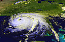
According to the latest advisory from the National Hurricane Center, Hurricane Bill is about 510 miles across. Hurricane force winds extend out 105 miles from the eye (that's one way). Tropical storm force winds will be felt up to 260 miles from the center. Sustained winds are currently 125 miles per hour, a strong Category 3 storm. It's good that the winds have fallen down a bit, although the NHC advisory says the storm could pick up strength again on Friday. The U.S. east coast and Bermuda will experience storm surge, and will very likely feel a lot of wind and rain.
The latest track seems to have Bill passing a bit further west of Bermuda than it showed earlier in the week. Of course, there's always a margin of error, hence the "cone of uncertainty" that appears around the forecast track on most maps.
If you're interested in reviewing the accuracy or inaccuracy of the National Hurricane Center's forecasts, here's a great place to go: the Graphics Archive. That link will take you to a list of choices. I like to use the 5-day forecast with cone of uncertainty. When you click on the link, you'll get a slideshow of all the forecast maps since the NHC has been tracking the storm. You can use the controls at left to STOP the automatic loop, then use the little arrow buttons to toggle one frame at a time. This is good because the size of the map changes sometimes, resulting in a kind of jump cut that can be disorienting.
It's very interesting to see how the storm's track changes while still generally staying within the "cone of uncertainty."
Otherwise, the tropics remain calm, after a somewhat surprising burst of activity over the past week.
I wish everyone well who's anywhere near the path of Hurricane Bill.
Thursday, August 20, 2009


Tuesday, August 18, 2009
Bermuda Officials Give Warning
A few hours after my last post, and the sports story has been replaced with "Breaking News: People urged to prepare for Hurricane Bill today."
It's about time.
It's about time.
Is Bermuda bracing for the blow?
I'm a little mystified by the Royal Gazette's coverage of Hurricane Bill. First of all, I went to the Bermuda's paper's website and it was the fourth item down. Top story (breaking news) was some sports story.
Then I read the article. They quote a Bermuda Weather Service forecaster as saying, "It is a long way away. If it does come up towards Bermuda, the forecast says that it will pass to the west of the Island."
Hurricane Ike passed about 350 miles south of Pensacola, and we had flooding from some storm surge. (I arrived at that 350 miles figure by looking at the storm's path. Pensacola is on the 30 latitude line and the storm passed on the 25 latitude line. One latitude line is about 70 miles, so by my calculations 5 latitude lines=350 miles.)
Looking at the satellite photos of Bill, if the storm's eye passes about 100 miles from Bermuda (as the aforementioned forecaster suggested), it's still going to be a nasty hit to the island. A hurricane is not a dot on a map. That's just the eye. Yes, the winds are usually worst right around the eye, but there's a lot of destructive power spread out over hundreds of miles. As well, the forecast has Bill tracking west of the island. You never want to be on the east side of a hurricane, at least not in the northern hemisphere.
In 2005, Katrina made landfall on the Mississippi Gulf Coast, about 152 miles west of Pensacola, and my power was out for three days. Not that I'm complaining, I'm just demonstrating that the reach of a major hurricane goes well beyond that little dot on the map.
I hope that the people of Bermuda are taking this more seriously than their newspaper seems to be and that they're stocking up and making plans to take themselves and their pets to the highest ground they can find.
I'll give the paper some points for including a checklist of supplies to buy and steps to take in advance of the storm, but they don't really seem to be stressing that the time to take action is now.
Then I read the article. They quote a Bermuda Weather Service forecaster as saying, "It is a long way away. If it does come up towards Bermuda, the forecast says that it will pass to the west of the Island."
Hurricane Ike passed about 350 miles south of Pensacola, and we had flooding from some storm surge. (I arrived at that 350 miles figure by looking at the storm's path. Pensacola is on the 30 latitude line and the storm passed on the 25 latitude line. One latitude line is about 70 miles, so by my calculations 5 latitude lines=350 miles.)
Looking at the satellite photos of Bill, if the storm's eye passes about 100 miles from Bermuda (as the aforementioned forecaster suggested), it's still going to be a nasty hit to the island. A hurricane is not a dot on a map. That's just the eye. Yes, the winds are usually worst right around the eye, but there's a lot of destructive power spread out over hundreds of miles. As well, the forecast has Bill tracking west of the island. You never want to be on the east side of a hurricane, at least not in the northern hemisphere.
In 2005, Katrina made landfall on the Mississippi Gulf Coast, about 152 miles west of Pensacola, and my power was out for three days. Not that I'm complaining, I'm just demonstrating that the reach of a major hurricane goes well beyond that little dot on the map.
I hope that the people of Bermuda are taking this more seriously than their newspaper seems to be and that they're stocking up and making plans to take themselves and their pets to the highest ground they can find.
I'll give the paper some points for including a checklist of supplies to buy and steps to take in advance of the storm, but they don't really seem to be stressing that the time to take action is now.
Monday, August 17, 2009
Brace Yourself, Bermuda
Bill is going to be a major hurricane when it passes by the little island of Bermuda in a few days. The only thing we can hope for is that the track continues to shift east. Since the winds are typically strong on the storm's east side, if Bill were to keep Bermuda to his left, the island might not suffer quite as much. It's still going to be bad.
Meanwhile, the Gulf Coast has been spared, for now. Claudette wasn't bad at all and was quickly downgraded after making landfall just after midnight. In Pensacola we had some rain, and it was quite a breezy day, but things weren't bad at all. Ana has dissipated and the National Hurricane Center is no longer issuing updates. It was surprising that Ana developed at all. That system was never really well-organized, which is good news for everyone in its path. Let's hope it continues to fall apart and doesn't re-form.
While hunting for information about these three systems, I discovered a new service which, for the moment at least, is free. Emicus is setting itself up to be a clearinghouse of information from difference community sources. If you're in a disaster area, you can send reports by iPhone or text message. They get feeds from Twitter, they have a tracking map for hurricanes and other dangerous weather situations, they offer checklists for disaster preparedness.... but what made me say, "Cool!" was they offer a quick and easy way to let the people important to you know that you're all right after a disaster.
Here's how it works: register on Emicus and create a list of emergency contacts. You can list phone number/text number/email address. Say a hurricane hits or an earthquake strikes. You're very busy and communication is spotty, but if you can get through a single text message, you can reach everyone on your list. Simply text "I'm Ok" plus a short personal message (like "I'm ok, a little roof damage, but we're fine") to 364287 (spells Emicus, clever huh?), and their system will forward it to everyone on your list. If all you have is a voice number, they'll even call and read it aloud. Isn't that a great idea?
I just registered and listed my mom and my mother-in-law so I know I have a way to reach them. You can list friends, family, co-workers, whoever it might be important to reach after a disaster. Here's a hint -- to enter your names and numbers in the box, you have to click "edit" on the right side of the screen, then it opens up all the fields to type into.
This service will save you time and ease the minds of your loved ones, friends, and colleagues when they're watching the devastation on the Weather Channel or CNN.
Meanwhile, the Gulf Coast has been spared, for now. Claudette wasn't bad at all and was quickly downgraded after making landfall just after midnight. In Pensacola we had some rain, and it was quite a breezy day, but things weren't bad at all. Ana has dissipated and the National Hurricane Center is no longer issuing updates. It was surprising that Ana developed at all. That system was never really well-organized, which is good news for everyone in its path. Let's hope it continues to fall apart and doesn't re-form.
While hunting for information about these three systems, I discovered a new service which, for the moment at least, is free. Emicus is setting itself up to be a clearinghouse of information from difference community sources. If you're in a disaster area, you can send reports by iPhone or text message. They get feeds from Twitter, they have a tracking map for hurricanes and other dangerous weather situations, they offer checklists for disaster preparedness.... but what made me say, "Cool!" was they offer a quick and easy way to let the people important to you know that you're all right after a disaster.
Here's how it works: register on Emicus and create a list of emergency contacts. You can list phone number/text number/email address. Say a hurricane hits or an earthquake strikes. You're very busy and communication is spotty, but if you can get through a single text message, you can reach everyone on your list. Simply text "I'm Ok" plus a short personal message (like "I'm ok, a little roof damage, but we're fine") to 364287 (spells Emicus, clever huh?), and their system will forward it to everyone on your list. If all you have is a voice number, they'll even call and read it aloud. Isn't that a great idea?
I just registered and listed my mom and my mother-in-law so I know I have a way to reach them. You can list friends, family, co-workers, whoever it might be important to reach after a disaster. Here's a hint -- to enter your names and numbers in the box, you have to click "edit" on the right side of the screen, then it opens up all the fields to type into.
This service will save you time and ease the minds of your loved ones, friends, and colleagues when they're watching the devastation on the Weather Channel or CNN.
Sunday, August 16, 2009
Triple Threat - Here's Claudette
While we were at Wal-mart, buying a few extra gallons of water and some fresh batteries, the low pressure system in the Gulf strengthened to Tropical Storm Claudette. That storm is offshore a little bit east of where I live. We have had some rain today and we'll see more overnight and tomorrow.
Ana has now been downgraded to a tropical depression, and according to the National Hurricane Center's track, they don't expect it to restrengthen to storm status. Let's hope they're right. The track also appears to be taking it further west, meaning folks in Mexico, Texas and Louisiana should pay particular heed to updates. The Caribbean islands, including Cuba, should expect wind and rain.
Bill is still a tropical storm but is expected to become the season's first hurricane. The track is still showing a northern turn. Most models show the storm remaining at sea, though some have it making landfall in Canada.
If you live in a coastal area, please watch for the latest advisories from the National Hurricane Center to assess whether any of these storms will affect you and your families.
Ana has now been downgraded to a tropical depression, and according to the National Hurricane Center's track, they don't expect it to restrengthen to storm status. Let's hope they're right. The track also appears to be taking it further west, meaning folks in Mexico, Texas and Louisiana should pay particular heed to updates. The Caribbean islands, including Cuba, should expect wind and rain.
Bill is still a tropical storm but is expected to become the season's first hurricane. The track is still showing a northern turn. Most models show the storm remaining at sea, though some have it making landfall in Canada.
If you live in a coastal area, please watch for the latest advisories from the National Hurricane Center to assess whether any of these storms will affect you and your families.
Saturday, August 15, 2009
Double Whammy: Two Named Storms
I looked at the National Hurricane Center website last night before going to bed, and we had three low pressure systems. The forecasters said one of those was likely to develop into a named storm.
Tonight, I finally get a chance to sign on, and now we have two named storms, Ana and Bill. Long term forecasts show Ana coming into the Gulf and heading right this way, with Bill veering north up the east coast.
Of course, these forecasts are just educated guesses. That's why they give us the cone of uncertainty, because a slight wobble today could mean several hundred miles difference in where the storm ends up a week from now.
I'm not a trained meteorologist or hurricane forecaster. I'm just a very interested amateur. As I'm analyzing the storm and its path, I like to go to the National Weather Service website and look at the 6-day outlook maps. Scroll down, and you'll see eight little maps that you can click on for a bigger image. The maps show how high fronts and low fronts are expected to form and move over the next week.
How this helps in tropical cyclone forecasting is that the cyclone aka tropical storm aka hurricane is a low pressure system, and lows are attracted to lows. A high pressure system, on the other hand, will push the tropical system away.
If you look at the map for six days out, you'll see a high pressure system that extends into Northwest Florida. That's good for me, here in Pensacola. That means Ana probably won't hit here, though we will probably feel some effects, such as rain bands, some wind, higher tides and possibly some flooding around the coast or rivers.
Now, I must point out that those highs and lows may not develop or move in the way the National Weather Service thinks they will. If that high doesn't sweep down into NW Florida at exactly the right time, the storm could come right this way. Plus, the highs and lows aren't the only things that affect tropical cyclones. Other atmospheric steering currents will affect movement, and water temperature affects intensity.
You can see Ana and Bill on the NWS outlook maps. They've got Ana moving across the southern tip of Florida (kind of like Andrew did in 1992), and that's why it shows as a Tropical Storm on the 5-day outlook and a Low on the 6-day. Crossing land weakens the storm.
The National Hurricane Center and Accuweather show Ana passing south of Florida and remaining a Tropical Storm as it enters the Gulf. That means it would remain at T.S. strength and possibly get even stronger, fueled by the Gulf's warmer waters.
Now, let's talk about Bill. Bill is expected to be a full-fledged hurricane by Monday. Most of the computer models show this storm curving to the north with a path that could affect Bermuda and/or New England and/or Canada's east coast. At this point, one model shows the storm making a sharp turn west and hitting the Carolinas. Sometimes a path that's really drastically different from all the other models means that the particular model either didn't account for something that all the others did or there's a error in the calculation somewhere. Or maybe that's the one model that got it right. Landfall is several days away and a lot of different factors will play into which way this storm goes.
If you live along the Gulf Coast or the Atlantic Coast, for the next week or so it's going to be important to pay attention to what's happening, take some preliminary steps to prepare, and be ready to do what it takes to protect your family and property.
Tonight, I finally get a chance to sign on, and now we have two named storms, Ana and Bill. Long term forecasts show Ana coming into the Gulf and heading right this way, with Bill veering north up the east coast.
Of course, these forecasts are just educated guesses. That's why they give us the cone of uncertainty, because a slight wobble today could mean several hundred miles difference in where the storm ends up a week from now.
I'm not a trained meteorologist or hurricane forecaster. I'm just a very interested amateur. As I'm analyzing the storm and its path, I like to go to the National Weather Service website and look at the 6-day outlook maps. Scroll down, and you'll see eight little maps that you can click on for a bigger image. The maps show how high fronts and low fronts are expected to form and move over the next week.
How this helps in tropical cyclone forecasting is that the cyclone aka tropical storm aka hurricane is a low pressure system, and lows are attracted to lows. A high pressure system, on the other hand, will push the tropical system away.
If you look at the map for six days out, you'll see a high pressure system that extends into Northwest Florida. That's good for me, here in Pensacola. That means Ana probably won't hit here, though we will probably feel some effects, such as rain bands, some wind, higher tides and possibly some flooding around the coast or rivers.
Now, I must point out that those highs and lows may not develop or move in the way the National Weather Service thinks they will. If that high doesn't sweep down into NW Florida at exactly the right time, the storm could come right this way. Plus, the highs and lows aren't the only things that affect tropical cyclones. Other atmospheric steering currents will affect movement, and water temperature affects intensity.
You can see Ana and Bill on the NWS outlook maps. They've got Ana moving across the southern tip of Florida (kind of like Andrew did in 1992), and that's why it shows as a Tropical Storm on the 5-day outlook and a Low on the 6-day. Crossing land weakens the storm.
The National Hurricane Center and Accuweather show Ana passing south of Florida and remaining a Tropical Storm as it enters the Gulf. That means it would remain at T.S. strength and possibly get even stronger, fueled by the Gulf's warmer waters.
Now, let's talk about Bill. Bill is expected to be a full-fledged hurricane by Monday. Most of the computer models show this storm curving to the north with a path that could affect Bermuda and/or New England and/or Canada's east coast. At this point, one model shows the storm making a sharp turn west and hitting the Carolinas. Sometimes a path that's really drastically different from all the other models means that the particular model either didn't account for something that all the others did or there's a error in the calculation somewhere. Or maybe that's the one model that got it right. Landfall is several days away and a lot of different factors will play into which way this storm goes.
If you live along the Gulf Coast or the Atlantic Coast, for the next week or so it's going to be important to pay attention to what's happening, take some preliminary steps to prepare, and be ready to do what it takes to protect your family and property.
Thursday, August 13, 2009
Ultimate Disaster Survival Guide
The former Invest 99 aka Tropical Depression 2 seems to be fizzling out. Meanwhile, off the coast of Africal, Invest 90 is gaining strength and heading straight towards the Caribbean, according to a number of computer models.
We'll be stocking up on canned goods and bottled water this weekend.
Now is the time to think about what you'll do in the aftermath of a disaster, and Popular Mechanics offers a great guide online. Survive Anything: Your Ultimate Guide to Disaster offers a number of great articles such as
We'll be stocking up on canned goods and bottled water this weekend.
Now is the time to think about what you'll do in the aftermath of a disaster, and Popular Mechanics offers a great guide online. Survive Anything: Your Ultimate Guide to Disaster offers a number of great articles such as
- "5 Steps to Get Ready for Disaster"
- "22 Steps to Save Yourself When Natural Disaster Hits"
- "4 Steps to Power Your Home When the Grid Fails"
Subscribe to:
Posts (Atom)